Landsat Collection 2 Level-2 Surface Temperature
Date modified: 14 February 2022
Product overview
Background
Digital Earth Africa (DE Africa) provides free and open access to a copy of Landsat Collection 2 Level-2 products over Africa. These products are produced and provided by the United States Geological Survey (USGS).
The Landsat series of Earth Observation satellites, jointly led by USGS and NASA, have been continuously acquiring images of the Earth’s land surface since 1972. DE Africa provides data from Landsat 5, 7, 8, and 9 satellites, including historical observations dating back to late 1980s and regularly updated new acquisitions.
New Level-2 Landsat 7, 8, and 9 data are available after approximately 25, 15, and 3 days, respectively, from acquisition. See Landsat Collection 2 Generation Timeline for details.
USGS Landsat Collection 2 was released early 2021 and offers improved processing, geometric accuracy, and radiometric calibration compared to previous Collection 1 products. The Level-2 products are endorsed by the Committee on Earth Observation Satellites (CEOS) to be Analysis Ready Data (CARD)-compliant. This internationally-recognised certification ensures these products have been processed to a minimum set of requirements and organised into a form that allows immediate analysis with a minimum of additional user effort and interoperability both through time and with other datasets.
USGS Landsat Collection 2 Level-2 includes:
Surface Reflectance
Surface Temperature
This document provides technical specifications for the Surface Temperature product. Information for the Surface Refletance product can be found in the Landsat Collection 2 Level-2 Surface Reflectance specification.
Surface temperature measures the Earth’s surface temperature and is an important geophysical parameter in global energy balance studies and hydrologic modeling. Surface temperature is also useful for monitoring crop and vegetation health, and extreme heat events such as natural disasters (e.g., volcanic eruptions, wildfires), and urban heat island effects.
A Jupyter Notebook which demonstrates loading and using Landsat surface temperature products in the Sandbox is also available.
Specifications
Spatial and temporal coverage
DE Africa provides Landsat Collection 2 Level-2 from Landsat 5, 7, 8, and 9 as seperate products. Relevant coverage and metadata can be viewed on DE Africa Metadata Exploer:
Table 1: Landsat Collection 2 Level-2 Surface Temperature product specifications
Satellite |
Landsat 5 |
Landsat 7 |
Landsat 8 |
Landsat 9 |
|---|---|---|---|---|
Instrument |
Multispectral Scanner (MSS), Thematic Mapper (TM) |
Enhanced Thematic Mapper (ETM+) |
Operational Land Imager (OLI), Thermal Infrared Sensor (TIRS) |
OLI-2, TIRS-2 |
Number of bands |
10 |
10 |
10 |
10 |
Cell size - X (metres) |
30 |
30 |
30 |
30 |
Cell size - Y (metres) |
30 |
30 |
30 |
30 |
Coordinate reference system |
Universal Transverse Mercator (UTM) |
UTM |
UTM |
UTM |
Temporal resolution |
Every 16 days |
Every 16 days |
Every 16 days |
Every 16 days |
Temporal range |
1984 – 2012 |
1999 – present |
2013 – present |
2021 – present |
Parent dataset |
||||
Update frequency |
NA (archive) |
Daily |
Daily |
Daily |
Measurements
Table 2: Landsat 5 and Landsat 7 Surface Temperature Level-2 measurements
Band ID |
Description |
Units |
Range |
Data type |
No data\(^\dagger\) |
Conversion\(^\ddagger\) |
|---|---|---|---|---|---|---|
ST_B6 |
Surface temperature band 6 (Thermal Infrared (TIR)) |
Kelvin |
|
|
|
0.00341802 * DN + 149.0 |
ST_TRAD |
Thermal radiance |
Wm\(^{-2}\)sr\(^{-1}\)\(\mu\)m\(^{-1}\) |
|
|
|
0.001 * DN |
ST_URAD |
Upwell radiance |
Wm\(^{-2}\)sr\(^{-1}\)\(\mu\)m\(^{-1}\) |
|
|
|
0.001 * DN |
ST_DRAD |
Downwell radiance |
Wm\(^{-2}\)sr\(^{-1}\)\(\mu\)m\(^{-1}\) |
|
|
|
0.001 * DN |
ST_ATRAN |
Atmospheric transmittance |
Unitless |
|
|
|
0.0001 * DN |
ST_EMIS |
Emissivity |
Unitless |
|
|
|
0.0001 * DN |
ST_EMSD |
Emissivity standard deviation |
Unitless |
|
|
|
0.0001 * DN |
ST_CDIST |
Distance to cloud |
Kilometers |
|
|
|
0.01 * DN |
QA_PIXEL |
Pixel quality |
Bit Index |
|
|
|
NA |
QA_RADSAT |
Radiometric saturation |
Bit Index |
|
|
|
NA |
ST_QA |
Surface temperature uncertainty |
Kelvin |
|
|
|
0.01 * DN |
\(^\dagger\) No data or fill value.
\(^\ddagger\) Physical measurement can be derived from the Digital Number (DN) stored in the product using the conversion equation listed.
More inforamtion can be found from the Landsat 4-7 Collection 2 Science Product Guide.
Table 3: Landsat 8 and Landsat 9 Level-2 Surface Temperature measurements
Landsat 8 and Landsat 9 Level-2 science products are generated using a different algorithm and have different output measurements compared to Landsat 5 and Landsat 7.
Band ID |
Description |
Units |
Range |
Data type |
No data\(^\dagger\) |
Conversion\(^\ddagger\) |
|---|---|---|---|---|---|---|
ST_B10 |
Surface temperature band 10 (TIR) |
Kelvin |
|
|
|
0.00341802 * DN + 149.0 |
ST_TRAD |
Thermal radiance |
Wm\(^{-2}\)sr\(^{-1}\)\(\mu\)m\(^{-1}\) |
|
|
|
0.001 * DN |
ST_URAD |
Upwell radiance |
Wm\(^{-2}\)sr\(^{-1}\)\(\mu\)m\(^{-1}\) |
|
|
|
0.001 * DN |
ST_DRAD |
Downwell radiance |
Wm\(^{-2}\)sr\(^{-1}\)\(\mu\)m\(^{-1}\) |
|
|
|
0.001 * DN |
ST_ATRAN |
Atmospheric transmittance |
Unitless |
|
|
|
0.0001 * DN |
ST_EMIS |
Emissivity |
Unitless |
|
|
|
0.0001 * DN |
ST_EMSD |
Emissivity standard deviation |
Unitless |
|
|
|
0.0001 * DN |
ST_CDIST |
Distance to cloud |
Kilometers |
|
|
|
0.01 * DN |
QA_PIXEL |
Pixel quality |
Bit Index |
|
|
|
NA |
QA_RADSAT |
Radiometric saturation |
Bit Index |
|
|
|
NA |
ST_QA |
Surface temperature uncertainty |
Kelvin |
|
|
|
0.01 * DN |
\(^\dagger\) No data or fill value.
\(^\ddagger\) Physical measurement can be derived from the Digital Number (DN) stored in the product using the conversion equation listed.
More inforamtion can be found from Landsat 8 OLI/TIRS Collection 2 Science Product Guide and Landsat 8-9 OLI/TIRS Collection 2 Level 2 Data Format Control Book
Quality assessment bands
Pixel quality assessment (QA_PIXEL) bands are generated by the CFMask algorithm. Different bit definitions are used because the cirrus band is only available on Landsat 8 and 9. This band is relevant to both Surface Reflectance and Surface Temperature products.
Table 4: Pixel quality assessment (QA_PIXEL) bit index.
Bit |
Landat 5 & 7 |
Landsat 8 & 9 |
Description Values |
|---|---|---|---|
0 |
Fill |
Fill |
0 for image data; 1 for fill data |
1 |
Dilated Cloud |
Dilated Cloud |
0 for cloud is not dilated or no cloud; 1 for cloud dilation |
2 |
Unused |
Cirrus |
0 for cirrus confidence is not; 1 for high confidence cirrus |
3 |
Cloud |
Cloud |
0 for cloud confidence is not high; 1 for high confidence cloud |
4 |
Cloud Shadow |
Cloud Shadow |
0 for Cloud Shadow Confidence is not high; 1 for high confidence cloud shadow |
5 |
Snow |
Snow |
0 for Snow/Ice Confidence is not high; 1 for high confidence snow cover |
6 |
Clear |
Clear |
0 if Cloud or Dilated Cloud bits are set; 1 if Cloud and Dilated Cloud bits are not set |
7 |
Water |
Water |
0 for land or cloud; 1 for water |
8-9 |
Cloud Confidence |
Cloud Confidence |
00 for no confidence level set; 01 Low confidence; 10 Medium confidence; 11 High confidence |
10-11 |
Cloud Shadow Confidence |
Cloud Shadow Confidence |
00 for no confidence level set; 01 Low confidence; 10 Reserved; 11 High confidence |
12-13 |
Snow/Ice Confidence |
Snow/Ice Confidence |
00 for no confidence level set; 01 Low confidence; 10 Reserved; 11 High confidence |
14-15 |
Unused |
Cirrus Confidence |
00 for no confidence level set; 01 Low confidence; 10 Reserved; 11 High confidence |
Radiometric saturation quality assessment (QA_RADSAT) bands are different for Landsat 5, 7 and 8/9 because the sensors have different spectral bands. This band is relevant to both Surface Reflectance and Surface Temperature products.
Table 5: Radiometric saturation quality assessment (QA_RADSAT) bit index.
Bit |
Landsat 5 |
Landsat 7 |
Landsat 8 & 9 |
Description Values |
|---|---|---|---|---|
0 |
Band 1 (Blue) |
Band 1 (Blue) |
Band 1 (Coastal) |
0 no saturation; 1 saturated data |
1 |
Band 2 (Green) |
Band 2 (Green) |
Band 2 (Blue) |
0 no saturation; 1 saturated data |
2 |
Band 3 (Red) |
Band 3 (Red) |
Band 3 (Green) |
0 no saturation; 1 saturated data |
3 |
Band 4 (NIR) |
Band 4 (NIR) |
Band 4 (Red) |
0 no saturation; 1 saturated data |
4 |
Band 5 (SWIR1) |
Band 5 (SWIR1) |
Band 5 (NIR) |
0 no saturation; 1 saturated data |
5 |
Band 6 (TIR) |
Band 6L (TIR)† |
Band 6 (SWIR1) |
0 no saturation; 1 saturated data |
6 |
Band 7 (SWIR2) |
Band 7 (SWIR2) |
Band 7 (SWIR2) |
0 no saturation; 1 saturated data |
7 |
Unused |
Unused |
Unused |
0 |
8 |
Unused |
Band 6H (TIR)‡ |
Band 9 (Cirrus) |
0 no saturation; 1 saturated data |
9 |
Dropped Pixel |
Dropped Pixel |
Unused |
0 Pixel present; 1 detector doesn’t have a value - no data |
10 |
Unused |
Unused |
Unused |
0 |
11 |
Unused |
Unused |
Terrain occlusion |
0 no terrain occlusion; 1 terrain occlusion |
12 |
Unused |
Unused |
Unused |
0 |
13 |
Unused |
Unused |
Unused |
0 |
14 |
Unused |
Unused |
Unused |
0 |
15 |
Unused |
Unused |
Unused |
0 |
\(^\dagger\), \(^\ddagger\) For Landsat 7 products, the Band 6 TOA brightness temperature product is generated from ETM+ Band 6 High gain (6H) and Band 6 Low gain (6L) merged together. The merged Band 6 is comprised of pixels that are not saturated in Band 6H. When Band 6H pixels are saturated with a brightness temperature outside of the 6H dynamic range (from 240K to 322K), they will be filled with pixels from the 6L band even if those pixels are saturated.
Processing
Landsat Collection 2 Level-2 products are processed by the USGS from Collection 2 Level-1 inputs. Landsat 5, 7, 8, and 9 surface temperature products are generated using the Landsat surface temperature algorithm.
Media and example images
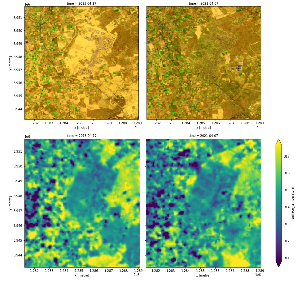
Figure 1: Landsat false color composites (highlighting vegetation, top row) and corresponding surface temperature measurements (in Kelvin, bottom row) over an area in Tripoli District, Libya.
Related services
References
License
There are no restrictions on Landsat data downloaded from the USGS; it can be used or redistributed as desired. USGS request that you include a statement of the data source when citing, copying, or reprinting USGS Landsat data or images.
Acknowledgements
Landsat Level- 2 Surface Temperature Science Product courtesy of the U.S. Geological Survey.
Data access
Amazon Web Services S3
Landsat Collection 2 Level-2 is available in AWS S3, sponsored by the Public Dataset Program.
Table 6: AWS data access details.
AWS S3 details |
|
|---|---|
Bucket ARD |
|
Region |
|
The bucket is in the AWS region af-south-1 (Cape Town). Additional region specifications can be applied as follows:
aws s3 ls --region=af-south-1 s3://deafrica-landsat/
The file paths follow the format collection02/level-2/standard/<sensor>/<year>/<path>/<row>/<scene_id>/.
Table 7: AWS file path convention.
File path element |
Description |
Example |
|---|---|---|
|
Landsat sensor name, |
|
|
Observation year |
|
|
Landsat orbit path id |
|
|
Landsat orbit row id |
|
|
Landsat scene id |
|
OGC Web Services (OWS)
This product is available through DE Africa’s OWS.
Table 8: OWS data access details.
OWS details |
|
|---|---|
Name |
|
Web Map Services (WMS) URL |
|
Web Coverage Service (WCS) URL |
|
Layer name |
|
Digital Earth Africa OWS details can be found at https://ows.digitalearth.africa/.
For instructions on how to connect to OWS, see this tutorial.
Open Data Cube (ODC)
The Landsat Collection 2 Level-2 products can be accessed through the Digital Earth Africa ODC API, which is available through the Digital Earth Africa Sandbox.
ODC product names: ls5_st, ls7_st, ls8_st, ls9_st
Specific bands of data can be called by using either the default names or any of a band’s alternative names, as listed in the table below. ODC Datacube.load commands without specified bands will load all bands.
Table 9: Landsat 5 and Landsat 7 Level-2 Surface Temperature (ODC product ls5_st and ls7_st) band names.
Band name |
Alternative names |
Fill value |
|---|---|---|
ST_B6 |
band_6, st, surface_temperature |
|
ST_TRAD |
trad, thermal_radiance |
|
ST_URAD |
urad, upwell_radiance |
|
ST_DRAD |
drad, downwell_radiance |
|
ST_ATRAN |
atran, atmospheric_transmittance |
|
ST_EMIS |
emis, emissivity |
|
ST_EMSD |
emsd, emissivity_stddev |
|
ST_CDIST |
cdist, cloud_distance |
|
QA_PIXEL |
pq, pixel_quality |
|
QA_RADSAT |
radsat, radiometric_saturation |
|
ST_QA |
st_qa, surface_temperature_quality |
|
Table 10: Landsat 8 and Landsat 9 Level-2 Surface Temperature (ODC product ls8_st and ls9_st) band names.
Band name |
Alternative names |
Fill value |
|---|---|---|
ST_B10 |
band_10, st, surface_temperature |
|
ST_TRAD |
trad, thermal_radiance |
|
ST_URAD |
urad, upwell_radiance |
|
ST_DRAD |
drad, downwell_radiance |
|
ST_ATRAN |
atran, atmospheric_transmittance |
|
ST_EMIS |
emis, emissivity |
|
ST_EMSD |
emsd, emissivity_stddev |
|
ST_CDIST |
cdist, cloud_distance |
|
QA_PIXEL |
pq, pixel_quality |
|
QA_RADSAT |
radsat, radiometric_saturation |
|
ST_QA |
st_qa, surface_temperature_quality |
|
Band names are case-sensitive.
For examples on how to use the ODC API, see the DE Africa example notebook repository.
Technical information
Surface Temperature
The surface temperature product is generated from the Landsat Collection 2 Level-1 thermal infrared bands, Top of Atmosphere (TOA) reflectance, TOA brightness temperature, Advanced Spaceborne Thermal Emission and Reflection Radiometer (ASTER) Global Emissivity Database (GED) data, ASTER Normalized Difference Vegetation Index (NDVI) data, and atmospheric profiles of geopotential height, specific humidity, and air temperature extracted from Goddard Earth Observing System (GEOS) Model Version 5 Forward Processing Instrument Teams (FP-IT) (for acquisitions from 2000 to present) or Modern Era Retrospective analysis for Research and Applications Version 2 (MERRA-2) (for acquisitions from 1982 to 1999).
For more information and caveats of the product, visit the Landsat Collection 2 Surface Temperature webpage.
The surface temperature product is provided at 30 m spatial sampling, however, the thermal sensors vary in spectral response, sensitivity and resolution.
Table 11: Landsat thermal sensors specification.
Satellite |
Sensor |
Spetral Band |
Wavelength (µm) |
Spatial Resolution (m) |
|---|---|---|---|---|
Landsat 8/9 |
Thermal Infrared Sensor (TIRS)/TIRS-2 |
10 |
10.60 - 11.19 |
100 |
11 |
11.50 - 12.51 |
100 |
||
Landsat 7 |
Enhanced Thematic Mapper Plus (ETM+) |
6 |
10.31 - 12.36 |
60 |
Landsat 5 |
Thematic Mapper (TM) |
6 |
10.40 - 12.50 |
120 |
The Level-2 product provides a number of intermediate and quality bands for surface temperature measurement. These bands may help interpret the results.
Table 12: Surface temperature relevant bands.
Name |
Explanation |
|---|---|
Surface temperature (ST) |
The temperature of the Earth’s surface in Kelvin (K). |
Thermal radiance (ST_TRAD) |
The values produced when thermal band reflectance is converted to radiance. |
Upwell radiance (ST_URAD) |
The amount of electromagnetic radiation reflected upward from the ground’s surface. |
Downwellradiance (ST_DRAD) |
The thermal energy radiated onto the ground by all objects in a hemisphere surrounding it. |
Atmospheric transmittance (ST_ATRAN) |
The ratio of the transmitted radiation to the total radiation incident upon the medium (atmosphere). |
Emissivity (ST_EMIS) |
The ratio of the energy radiated from a material’s surface to that radiated from a blackbody. |
Emissivity_stdev (ST_EMSD) |
The extent of deviation of the emissivity product. This layer is used along with cloud_distance to create the quality assessment product. |
Distance to cloud (ST_CDIST) |
The distance, in kilometers, that a pixel is from the nearest cloud pixel. This layer is used along with emissivity_stdev to create the quality assessment product. |
Surface temperature uncertainty (ST_QA) |
Provides the Surface Temperature product uncertainty using a combination of uncertainty values and distance to cloud values. |