Landsat Collection 2 Level-2 Surface Reflectance
Date modified: 14 February 2022
Product overview
Background
Digital Earth Africa (DE Africa) provides free and open access to a copy of Landsat Collection 2 Level-2 products over Africa. These products are produced and provided by the United States Geological Survey (USGS).
The Landsat series of Earth Observation satellites, jointly led by USGS and NASA, have been continuously acquiring images of the Earth’s land surface since 1972. DE Africa provides data from Landsat 5, 7, 8, and 9 satellites, including historical observations dating back to late 1980s and regularly updated new acquisitions.
New Level-2 Landsat 7, 8, and 9 data are available after approximately 25, 15, and 3 days, respectively, from acquisition. See Landsat Collection 2 Generation Timeline for details.
USGS Landsat Collection 2 was released early 2021 and offers improved processing, geometric accuracy, and radiometric calibration compared to previous Collection 1 products. The Level-2 products are endorsed by the Committee on Earth Observation Satellites (CEOS) to be Analysis Ready Data (CARD)-compliant. This internationally-recognised certification ensures these products have been processed to a minimum set of requirements and organised into a form that allows immediate analysis with a minimum of additional user effort and interoperability both through time and with other datasets.
USGS Landsat Collection 2 Level-2 includes:
Surface Reflectance
Surface Temperature
This document provides technical specifications for the Surface Reflectance product. Information for the Surface Temperature product can be found in the Landsat Collection 2 Level-2 Surface Temperature specification.
Surface reflectance is the fraction of incoming solar radiation that is reflected from Earth’s surface. Variations in satellite measured radiance due to atmospheric properties have been corrected for so images acquired over the same area at different times are comparable and can be used readily to detect changes on Earth’s surface.
A Jupyter Notebook which demonstrates loading and using Landsat surface reflectance products in the Sandbox is also available.
Specifications
Spatial and temporal coverage
DE Africa provides Landsat Collection 2 Level-2 from Landsat 5, 7, 8, and 9 as seperate products. Relevant coverage and metadata can be viewed on DE Africa Metadata Exploer:
Table 1: Landsat Collection 2 Level-2 Surface Reflectance product specifications
Satellite |
Landsat 5 |
Landsat 7 |
Landsat 8 |
Landsat 9 |
|---|---|---|---|---|
Instrument |
Multispectral Scanner (MSS), Thematic Mapper (TM) |
Enhanced Thematic Mapper (ETM+) |
Operational Land Imager (OLI), Thermal Infrared Sensor (TIRS) |
OLI-2, TIRS-2 |
Number of bands |
10 |
10 |
10 |
10 |
Cell size - X (metres) |
30 |
30 |
30 |
30 |
Cell size - Y (metres) |
30 |
30 |
30 |
30 |
Coordinate reference system |
Universal Transverse Mercator (UTM) |
UTM |
UTM |
UTM |
Temporal resolution |
Every 16 days |
Every 16 days |
Every 16 days |
Every 16 days |
Temporal range |
1984 – 2012 |
1999 – present |
2013 – present |
2021 – present |
Parent dataset |
||||
Update frequency |
NA (archive) |
Daily |
Daily |
Daily |
Measurements
Table 2: Landsat 5 and Landsat 7 Level-2 Surface Reflectance measurements
Band ID |
Description |
Units |
Range |
Data type |
No data\(^\dagger\) |
Conversion\(^\ddagger\) |
|---|---|---|---|---|---|---|
SR_B1 |
Surface reflectance band 1 (Blue) |
Unitless |
|
|
|
2.75e-05 * DN - 0.2 |
SR_B2 |
Surface reflectance band 2 (Green) |
Unitless |
|
|
|
2.75e-05 * DN - 0.2 |
SR_B3 |
Surface reflectance band 3 (Red) |
Unitless |
|
|
|
2.75e-05 * DN - 0.2 |
SR_B4 |
Surface reflectance band 4 (Near-Infrared (NIR)) |
Unitless |
|
|
|
2.75e-05 * DN - 0.2 |
SR_B5 |
Surface reflectance band 5 (Short Wavelength Infrared (SWIR) 1) |
Unitless |
|
|
|
2.75e-05 * DN - 0.2 |
SR_B7 |
Surface reflectance band 7 (SWIR 2) |
Unitless |
|
|
|
2.75e-05 * DN - 0.2 |
QA_PIXEL |
Pixel quality |
Bit Index |
|
|
|
NA |
QA_RADSAT |
Radiometric saturation |
Bit Index |
|
|
|
NA |
SR_ATMOS _OPACITY |
Atmospheric opacity |
Unitless |
|
|
|
0.001 * DN |
SR_CLOUD _QA |
Cloud mask quality |
Bit Index |
|
|
|
NA |
\(^\dagger\) No data or fill value.
\(^\ddagger\) Physical measurement can be derived from the Digital Number (DN) stored in the product using the conversion equation listed.
More inforamtion can be found from the Landsat 4-7 Collection 2 Science Product Guide.
Table 3: Landsat 8 and Landsat 9 Level-2 Surface Reflectance measurements
Landsat 8 and Landsat 9 Level-2 science products are generated using a different algorithm and have different output measurements compared to Landsat 5 and Landsat 7.
Band ID |
Description |
Units |
Range |
Data type |
No data\(^\dagger\) |
Conversion\(^\ddagger\) |
|---|---|---|---|---|---|---|
SR_B1 |
Surface reflectance band 1 (Coastal Aerosol) |
Unitless |
|
|
|
2.75e-05 * DN - 0.2 |
SR_B2 |
Surface reflectance band 2 (Blue) |
Unitless |
|
|
|
2.75e-05 * DN - 0.2 |
SR_B3 |
Surface reflectance band 3 (Green) |
Unitless |
|
|
|
2.75e-05 * DN - 0.2 |
SR_B4 |
Surface reflectance band 4 (Red) |
Unitless |
|
|
|
2.75e-05 * DN - 0.2 |
SR_B5 |
Surface reflectance band 5 (NIR) |
Unitless |
|
|
|
2.75e-05 * DN - 0.2 |
SR_B6 |
Surface reflectance band 6 (SWIR 1) |
Unitless |
|
|
|
2.75e-05 * DN - 0.2 |
SR_B7 |
Surface reflectance band 7 (SWIR 2) |
Unitless |
|
|
|
2.75e-05 * DN - 0.2 |
QA_PIXEL |
Pixel quality |
Bit Index |
|
|
|
NA |
QA_RADSAT |
Radiometric saturation |
Bit Index |
|
|
|
NA |
SR_QA _AEROSOL |
Aerosol level |
Bit Index |
|
|
|
NA |
\(^\dagger\) No data or fill value.
\(^\ddagger\) Physical measurement can be derived from the Digital Number (DN) stored in the product using the conversion equation listed.
More inforamtion can be found from Landsat 8 OLI/TIRS Collection 2 Science Product Guide and Landsat 8-9 OLI/TIRS Collection 2 Level 2 Data Format Control Book
Quality assessment bands
Pixel quality assessment (QA_PIXEL) bands are generated by the CFMask algorithm. Different bit definitions are used because the cirrus band is only available on Landsat 8 and 9. This band is relevant to both Surface Reflectance and Surface Temperature products.
Table 4: Pixel quality assessment (QA_PIXEL) bit index.
Bit |
Landat 5 & 7 |
Landsat 8 & 9 |
Description Values |
|---|---|---|---|
0 |
Fill |
Fill |
0 for image data; 1 for fill data |
1 |
Dilated Cloud |
Dilated Cloud |
0 for cloud is not dilated or no cloud; 1 for cloud dilation |
2 |
Unused |
Cirrus |
0 for cirrus confidence is not; 1 for high confidence cirrus |
3 |
Cloud |
Cloud |
0 for cloud confidence is not high; 1 for high confidence cloud |
4 |
Cloud Shadow |
Cloud Shadow |
0 for Cloud Shadow Confidence is not high; 1 for high confidence cloud shadow |
5 |
Snow |
Snow |
0 for Snow/Ice Confidence is not high; 1 for high confidence snow cover |
6 |
Clear |
Clear |
0 if Cloud or Dilated Cloud bits are set; 1 if Cloud and Dilated Cloud bits are not set |
7 |
Water |
Water |
0 for land or cloud; 1 for water |
8-9 |
Cloud Confidence |
Cloud Confidence |
00 for no confidence level set; 01 Low confidence; 10 Medium confidence; 11 High confidence |
10-11 |
Cloud Shadow Confidence |
Cloud Shadow Confidence |
00 for no confidence level set; 01 Low confidence; 10 Reserved; 11 High confidence |
12-13 |
Snow/Ice Confidence |
Snow/Ice Confidence |
00 for no confidence level set; 01 Low confidence; 10 Reserved; 11 High confidence |
14-15 |
Unused |
Cirrus Confidence |
00 for no confidence level set; 01 Low confidence; 10 Reserved; 11 High confidence |
Radiometric saturation quality assessment (QA_RADSAT) bands are different for Landsat 5, 7 and 8/9 because the sensors have different spectral bands. This band is relevant to both Surface Reflectance and Surface Temperature products.
Table 5: Radiometric saturation quality assessment (QA_RADSAT) bit index.
Bit |
Landsat 5 |
Landsat 7 |
Landsat 8 & 9 |
Description Values |
|---|---|---|---|---|
0 |
Band 1 (Blue) |
Band 1 (Blue) |
Band 1 (Coastal) |
0 no saturation; 1 saturated data |
1 |
Band 2 (Green) |
Band 2 (Green) |
Band 2 (Blue) |
0 no saturation; 1 saturated data |
2 |
Band 3 (Red) |
Band 3 (Red) |
Band 3 (Green) |
0 no saturation; 1 saturated data |
3 |
Band 4 (NIR) |
Band 4 (NIR) |
Band 4 (Red) |
0 no saturation; 1 saturated data |
4 |
Band 5 (SWIR1) |
Band 5 (SWIR1) |
Band 5 (NIR) |
0 no saturation; 1 saturated data |
5 |
Band 6 (TIR) |
Band 6L (TIR)† |
Band 6 (SWIR1) |
0 no saturation; 1 saturated data |
6 |
Band 7 (SWIR2) |
Band 7 (SWIR2) |
Band 7 (SWIR2) |
0 no saturation; 1 saturated data |
7 |
Unused |
Unused |
Unused |
0 |
8 |
Unused |
Band 6H (TIR)‡ |
Band 9 (Cirrus) |
0 no saturation; 1 saturated data |
9 |
Dropped Pixel |
Dropped Pixel |
Unused |
0 Pixel present; 1 detector doesn’t have a value - no data |
10 |
Unused |
Unused |
Unused |
0 |
11 |
Unused |
Unused |
Terrain occlusion |
0 no terrain occlusion; 1 terrain occlusion |
12 |
Unused |
Unused |
Unused |
0 |
13 |
Unused |
Unused |
Unused |
0 |
14 |
Unused |
Unused |
Unused |
0 |
15 |
Unused |
Unused |
Unused |
0 |
\(^\dagger\), \(^\ddagger\) For Landsat 7 products, the Band 6 TOA brightness temperature product is generated from ETM+ Band 6 High gain (6H) and Band 6 Low gain (6L) merged together. The merged Band 6 is comprised of pixels that are not saturated in Band 6H. When Band 6H pixels are saturated with a brightness temperature outside of the 6H dynamic range (from 240K to 322K), they will be filled with pixels from the 6L band even if those pixels are saturated.
For Landsat 5 and 7, another cloud mask band (SR_CLOUD_QA) is available but is less accurate than the QA_PIXEL band.
Table 6: Landsat 5 and Landsat 7 cloud mask (SR_CLOUD_QA) bit index.
Bit |
Attribute |
|---|---|
0 |
Dark Dense Vegetation (DDV) |
1 |
Cloud |
2 |
Cloud shadow |
3 |
Adjacent to cloud |
4 |
Snow |
5 |
Water |
6 |
Unused |
7 |
Unused |
For Landsat 8 and 9, aerosol retrieval information that may have impacted the product is provided in a SR_Aerosol_QA band. The default “Aerosol Level” is Climatology (00), which means no aerosol correction was applied. Pixels with an “Aerosol Level” classified as high are not recommended for use.
Table 7: Landsat 8 and Landsat 9 aerosol level (SR_Aerosol_QA) bit index.
Bit |
Flag |
Description Values |
|---|---|---|
0 |
Fill |
0 Pixel is not fill; 1 Pixel is fill |
1 |
Valid aerosol retrieval |
0 Pixel retrieval is not valid; 1 Pixel retrieval is valid |
2 |
Water |
0 Pixel is not water; 1 Pixel is water |
3 |
Unused |
0 |
4 |
Unused |
0 |
5 |
Interpolated Aerosol |
0 Pixel is not aerosol interpolated; 1 Pixel is aerosol interpolated |
6-7 |
Aerosol Level |
00 Climatology; 01 Low; 10 Medium; 11 High |
Processing
Landsat Collection 2 Level-2 products are processed by the USGS from Collection 2 Level-1 inputs. Landsat 8-9 OLI surface reflectance products are generated using the Land Surface Reflectance Code (LaSRC) algorithm. Landsat 4-5 TM and Landsat 7 ETM+ surface reflectance products are generated using the Landsat Ecosystem Disturbance Adaptive Processing System (LEDAPS) algorithm.
Media and example images
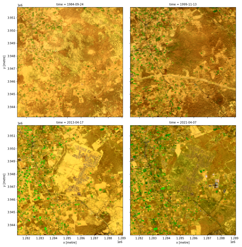
Figure 1: Landsat false color composites (highlighting vegetation) over an area in Tripoli District, Libya, showing changes between selected dates from 1984 to 2021.
Related services
References
License
There are no restrictions on Landsat data downloaded from the USGS; it can be used or redistributed as desired. USGS request that you include a statement of the data source when citing, copying, or reprinting USGS Landsat data or images.
Acknowledgements
Landsat Level- 2 Surface Reflectance Science Product courtesy of the U.S. Geological Survey.
Data access
Amazon Web Services S3
Landsat Collection 2 Level-2 is available in AWS S3, sponsored by the Public Dataset Program.
Table 8: AWS data access details.
AWS S3 details |
|
|---|---|
Bucket ARD |
|
Region |
|
The bucket is in the AWS region af-south-1 (Cape Town). Additional region specifications can be applied as follows:
aws s3 ls --region=af-south-1 s3://deafrica-landsat/
The file paths follow the format collection02/level-2/standard/<sensor>/<year>/<path>/<row>/<scene_id>/.
Table 9: AWS file path convention.
File path element |
Description |
Example |
|---|---|---|
|
Landsat sensor name, |
|
|
Observation year |
|
|
Landsat orbit path id |
|
|
Landsat orbit row id |
|
|
Landsat scene id |
|
OGC Web Services (OWS)
This product is available through DE Africa’s OWS.
Table 10: OWS data access details.
OWS details |
|
|---|---|
Name |
|
Web Map Services (WMS) URL |
|
Web Coverage Service (WCS) URL |
|
Layer name |
|
Digital Earth Africa OWS details can be found at https://ows.digitalearth.africa/.
For instructions on how to connect to OWS, see this tutorial.
Open Data Cube (ODC)
The Landsat Collection 2 Level-2 products can be accessed through the Digital Earth Africa ODC API, which is available through the Digital Earth Africa Sandbox.
ODC product names: ls5_sr, ls7_sr, ls8_sr, ls9_sr
Specific bands of data can be called by using either the default names or any of a band’s alternative names, as listed in the table below. ODC Datacube.load commands without specified bands will load all bands.
Table 11: Landsat 5 and Landsat 7 Level-2 Surface Reflectance (ODC product ls5_sr and ls7_sr) band names.
Band name |
Alternative names |
Fill value |
|---|---|---|
SR_B1 |
band_1, blue |
|
SR_B2 |
band_2, green |
|
SR_B3 |
band_3, red |
|
SR_B4 |
band_4, nir |
|
SR_B5 |
band_5, swir_1 |
|
SR_B7 |
band_7, swir_2 |
|
QA_PIXEL |
pq, pixel_quality |
|
QA_RADSAT |
radsat, radiometric_saturation |
|
SR_ATMOS_OPACITY |
atmos_opacity |
|
SR_CLOUD_QA |
cloud_qa |
|
Table 12: Landsat 8 and Landsat 9 Level-2 Surface Reflectance (ODC product ls8_sr and ls9_sr) band names.
Band name |
Alternative names |
Fill value |
|---|---|---|
SR_B1 |
band_1, coastal_aerosol |
|
SR_B2 |
band_2, blue |
|
SR_B3 |
band_3, green |
|
SR_B4 |
band_4, red |
|
SR_B5 |
band_5, nir |
|
SR_B6 |
band_6, swir_1 |
|
SR_B7 |
band_7, swir_2 |
|
QA_PIXEL |
pq, pixel_quality |
|
QA_RADSAT |
radsat, radiometric_saturation |
|
SR_QA_AEROSOL |
qa_aerosol, aerosol_qa |
|
Band names are case-sensitive.
For examples on how to use the ODC API, see the DE Africa example notebook repository.
Technical information
Surface Reflectance
The surface reflectance products for Landat 5, 7, 8, and 9 are generated using two different methods.
Landsat 5 TM and Landsat 7 ETM+ Collection 2 Surface Reflectance are generated using the Landsat Ecosystem Disturbance Adaptive Processing System (LEDAPS) algorithm. The software applies Moderate Resolution Imaging Spectroradiometer (MODIS) atmospheric correction routines to Level-1 data products. Water vapor, ozone, atmospheric height, aerosol optical thickness, and digital elevation are input with Landsat data to the Second Simulation of a Satellite Signal in the Solar Spectrum (6S) radiative transfer models to generate top of atmosphere (TOA) reflectance, surface reflectance, TOA brightness temperature, and masks for clouds, cloud shadows, adjacent clouds, land, and water.
Landsat 8 and Landsat 9 OLI Collection 2 Surface Reflectance data are generated using the Land Surface Reflectance Code (LaSRC), which makes use of the coastal aerosol band to perform aerosol inversion tests, uses auxiliary climate data from MODIS, and a unique radiative transfer model.
For more information on the different processing algorithms and caveats of the products, visit the Landsat Collection 2 Surface Reflectance webpage.