Modèle numérique d’objets (MNE) de Copernic (COP-DEM)
Date de modification : 9 mai 2025
Présentation du produit
Aperçu
Le MNT Copernicus est un modèle numérique de surface (MNS) qui représente la surface de la Terre. Le MNT Copernicus est fourni par l’Agence spatiale européenne (ESA) dans 3 cas différents :
COP-DEM-EEA-10 : offre une couverture des États membres de l’Espace économique européen (EEE) et des 6 pays coopérants avec une résolution spatiale de 0,3 seconde d’arc (~10 m)
COP-DEM-GLO-30 : offre une couverture mondiale avec une résolution spatiale de 1,0 seconde d’arc (~30 m)
COP-DEM-GLO-90 : offre une couverture mondiale avec une résolution spatiale de 3,0 secondes d’arc (~90 m)
Il existe deux instances du MNT Copernicus COP-DEM-GLO-30 : COP-DEM-GLO-30-R et COP-DEM-GLO-30 Public. COP-DEM-GLO-30 Public offre une couverture mondiale limitée à une résolution spatiale de 1,0 seconde d’arc (~30 m), car un petit sous-ensemble de tuiles couvrant des pays spécifiques n’est pas encore rendu public par le programme Copernicus. La liste des pays présentant des contraintes en termes de droits d’accès est disponible ici <https://sentinel.esa.int/documents/247904/4624006/Non-released-tiles-GLO-30-PUBLIC-Dec.xlsx>. COP-DEM-GLO-30-R offre une couverture mondiale complète, mais n’est accessible qu’aux utilisateurs appartenant aux catégories d’utilisateurs autorisés telles que définies dans la « licence applicable <https://s3.waw3-1.cloudferro.com/swift/v1/portal_uploads_prod/CSCDA_ESA_Mission-specific_Annex_31_Oct_22_latest.pdf> »__.
Digital Earth Africa offre un accès gratuit et ouvert aux produits COP-DEM-GLO-30 Public et COP-DEM-GLO-90 pour l’Afrique. Pour plus d’informations sur ces produits, consultez le site web Copernicus DEM <https://doi.org/10.5270/ESA-c5d3d65> et le manuel Copernicus DEM Product Handbook <https://dataspace.copernicus.eu/sites/default/files/media/files/2024-06/geo1988-copernicusdem-spe-002_producthandbook_i5.0.pdf>.
Un Jupyter Notebook qui démontre le chargement et l’utilisation des ensembles de données DEM dans le Sandbox est également disponible.
Spécifications
Couverture spatiale et temporelle
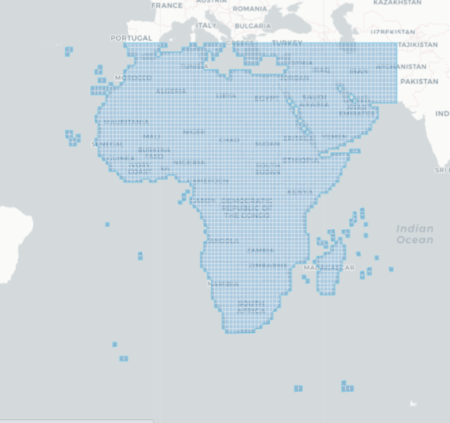
Les métadonnées pertinentes pour les produits publics COP-DEM-GLO-30 et COP-DEM-GLO-90, ainsi que leurs étendues temporelle et géographique, peuvent être consultées sur l’explorateur interactif de métadonnées DE Africa, ici <https://explorer.digitalearth.africa/products/dem_cop_30> et ici <https://explorer.digitalearth.africa/products/dem_cop_90>. Les données sont disponibles pour les régions ombrées en bleu.
Tableau 1 : Spécifications publiques des produits COP-DEM-GLO-30 et COP-DEM-GLO-90
Spécification |
||
|---|---|---|
Nom du produit |
|
|
Taille de la cellule - X (secondes d’arc) |
1,0 (~30 m) |
3.0 (~90 m) |
Taille de la cellule - Y (secondes d’arc) |
1,0 (~30 m) |
3.0 (~90 m) |
Système de référence de coordonnées |
EPSG: 4326 |
EPSG: 4326 |
Fréquence de mise à jour |
Aucun, sauf si la liste des tuiles publiques change. |
Aucun |
Figure 1 : Étendue géographique publique du COP-DEM-GLO-30
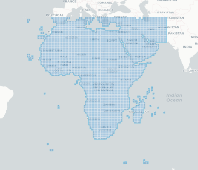
Figure 2 : Étendue géographique de COP-DEM-GLO-90
Mesures
Tableau 2 : Mesures des produits COP-DEM-GLO-30 Public et COP-DEM-GLO-90
Nom du produit |
ID de la bande |
Description |
Unités |
Type de données |
Aucune valeur de données |
|---|---|---|---|---|---|
|
élévation |
Données d’élévation |
|
|
|
|
élévation |
Données d’élévation |
|
|
|
Traitement
Le MNT Copernicus est dérivé d’un MNS modifié, WorldDEM, basé sur les données satellitaires radar acquises lors de la mission TanDEM-X. L’aplatissement des plans d’eau et le débit constant des rivières ont été pris en compte dans ce MNT modifié. Les lignes de côte et les traits de côte, ainsi que des éléments spécifiques tels que les aéroports et les structures de terrain non plausibles, ont également été modifiés. Le MNT modifié a également été complété localement avec les MNT suivants : ASTER, SRTM90, SRTM30, SRTM30plus, GMTED2010, MNT radargrammétrique TerraSAR-X et ALOS World 3D-30m. Le processus de génération et d’édition du produit Copernicus DEM est décrit dans le « Manuel du produit <https://dataspace.copernicus.eu/sites/default/files/media/files/2024-06/geo1988-copernicusdem-spe-002_producthandbook_i5.0.pdf> ».
Médias et exemples d’images
Figure 3 : Données publiques d’élévation COP-DEM-GLO-30 pour le mont Kilimandjaro
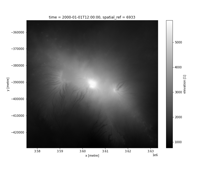
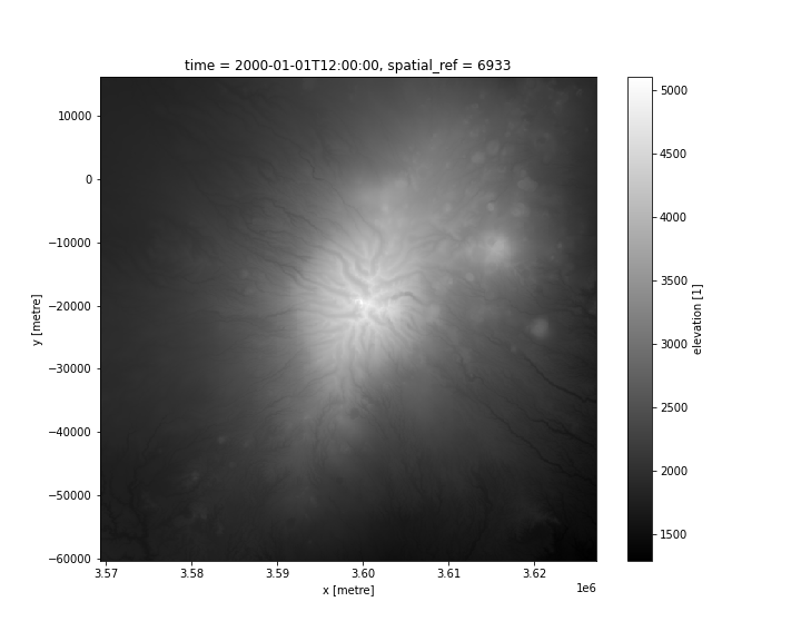
Figure 4 : Données d’élévation COP-DEM-GLO-90 pour le mont Kenya
Références
Le site Web Copernicus DEM <https://doi.org/10.5270/ESA-c5d3d65>`__
Manuel du produit Copernicus DEM <https://dataspace.copernicus.eu/sites/default/files/media/files/2024-06/geo1988-copernicusdem-spe-002_producthandbook_i5.0.pdf>`__
Licence et Remerciements
Le jeu de données GLO-90 est disponible dans le monde entier avec une licence gratuite. Le jeu de données GLO-30 est disponible dans le monde entier avec une licence gratuite, à l’exception de deux pays, répertoriés dans une liste dédiée <https://spacedata.copernicus.eu/documents/20126/0/COP-DEM_delivery_sheet_v0.9.xlsx/9812e3a5-300d-a0ef-1c52-4d55391eaed8?t=1630080852713> et disponibles dans le jeu de données COP-DEM_GLO-30-R. Les licences complètes sont disponibles ici <https://s3.waw3-1.cloudferro.com/swift/v1/portal_uploads_prod/CSCDA_ESA_Mission-specific_Annex_31_Oct_22_latest.pdf>.
Accès aux données
Services Web Amazon S3
Les instances publiques GLO-30 et GLO-90 du DEM Copernicus sont disponibles dans AWS S3 sponsorisé par le « Public Dataset Program <https://registry.opendata.aws/copernicus-dem/> »__.
Tableau 3 : Détails de l’accès aux données publiques Copernicus DEM GLO-30 et AWS GLO-90
Détails AWS S3 |
||
|---|---|---|
Produit |
GLO-30 Public |
GLO-90 |
Seau ARD |
|
|
Région |
« eu-central-1 » |
« eu-central-1 » |
Les chemins d’accès aux fichiers suivent le format de données de base : « Copernicus_DSM_COG_[résolution]_[northing]_[easting]_DEM/ » par exemple « s3://copernicus-dem-90m/Copernicus_DSM_COG_30_S90_00_W178_00_DEM/ »
Tableau 4 : Convention de chemin d’accès au fichier AWS
Élément de chemin de fichier |
Description |
Exemple |
|---|---|---|
« résolution » |
Résolution en secondes d’arc. |
« 10 » pour GLO-30 et « 30 » pour GLO-90 |
|
Il s’agit de l’ordonnée du centre des pixels les plus bas dans les fichiers d’origine. |
|
|
Il s’agit de l’est du centre des pixels les plus à gauche. |
|
Services Web OGC (OWS)
Ces instances publiques GLO-30 et GLO-90 du DEM Copernicus sont disponibles via l’OWS de DE Africa.
Tableau 5 : Détails d’accès aux données OWS.
Détails de l’OWS |
|
|---|---|
Nom |
« DE Africa Services » |
URL des services de cartographie Web (WMS) |
|
URL du service de couverture Web (WCS) |
|
Noms des calques |
|
Les détails de Digital Earth Africa OWS peuvent être trouvés sur https://ows.digitalearth.africa/.
Pour obtenir des instructions sur la façon de se connecter à OWS, consultez « ce tutoriel <../web_services/index.ipynb> ».
Open Data Cube (ODC)
Les instances GLO-30 Public et GLO-90 du DEM Copernicus sont accessibles via l’API ODC de Digital Earth Africa, qui est disponible via le Digital Earth Africa Sandbox.
Noms de produits ODC : dem_cop_30, dem_cop_90
Des bandes de données spécifiques peuvent être appelées en utilisant soit les noms par défaut, soit l’un des noms alternatifs d’une bande, comme indiqué dans le tableau ci-dessous. Les commandes ODC Datacube.load sans bandes spécifiées chargeront toutes les bandes.
Tableau 6 : noms de bandes des produits ODC dem_cop_30 et dem_cop_90
Produit |
Nom du groupe |
Noms alternatifs |
Remplir la valeur |
|---|---|---|---|
|
élévation |
NaN |
NaN |
|
élévation |
NaN |
NaN |
Informations techniques
Le MNE Copernicus a été validé à l’aide du système d’altimètre laser géoscientifique (GLAS) du satellite d’élévation des glaces, des nuages et des terres émergées (ICESat) de la NASA. L’erreur quadratique moyenne (RMSE) globale est de 1,68 mètre. L’évaluation de la précision est divisée en deux parties, car les régions couvertes de glace doivent être traitées différemment des régions non couvertes de glace, décrites dans le rapport de validation <https://s3.waw3-1.cloudferro.com/swift/v1/portal_uploads_prod/GEO1988-CopernicusDEM-RP-001_ValidationReport_I3.0_08.2024.pdf>`__.