Mission de topographie radar de la navette spatiale (SRTM) Modèle numérique d’élévation global de 1 seconde d’arc et dérivés DEM
Présentation du produit
Aperçu
Le modèle numérique de surface (MNT) global de 1 seconde d’arc (~30 mètres) de la mission NASA Making Earth System Data Records for Use in Research Environments (MEaSUREs) Shuttle Radar Topography Mission (SRTM) est archivé et distribué par le Land Processes Distributed Active Archive Center (LP DAAC). Cet ensemble de données est le résultat d’un effort collaboratif de la National Aeronautics and Space Administration (NASA) et de la National Geospatial-Intelligence Agency (NGA, anciennement connue sous le nom de National Imagery and Mapping Agency, ou NIMA), ainsi que de la participation des agences spatiales allemande et italienne. L’objectif principal de la création de cet ensemble de données était d’éliminer les vides présents dans les versions antérieures des données d’élévation SRTM.
Digital Earth Africa offre un accès gratuit et ouvert à une copie du produit SRTM DEM de la NASA version 3 sur l’Afrique.
Digital Earth Africa also produces and maintains free and open access to the SRTM DEM Derivatives product over Africa as a continental service.
These derivatives include slope, multi-resolution valley bottom flatness, multi-resolution ridge top flatness and topographic position. Slope and topographic position are provided at two spatial scales to represent local terrain variability and broader landform context. This product was generated by Digital Earth Africa from the Shuttle Radar Topography Mission (SRTM) v3.0 1 arc-second Digital Elevation Model.
Un Jupyter Notebook qui démontre le chargement et l’utilisation des ensembles de données DEM dans le Sandbox est également disponible.
Spécifications
Couverture spatiale et temporelle
Les métadonnées pertinentes pour le SRTM DEM et les produits dérivés du SRTM DEM peuvent être consultées sur l’explorateur de métadonnées DE Africa ici et ici.
Tableau 1 : Spécifications des produits SRTM DEM et SRTM DEM Derivatives
Spécification |
||
|---|---|---|
Nom du produit |
|
|
Taille de la cellule - X |
0,000278° (~30 m) |
30 m |
Taille de la cellule - Y |
0,000278° (~30 m) |
30 m |
Système de référence de coordonnées |
EPSG:4326 |
EPSG:6933 |
Résolution temporelle |
Plusieurs jours |
Plusieurs jours |
Étendue temporelle |
2000-02-11 au 2000-02-21 |
2000-02-11 au 2000-02-21 |
Fréquence de mise à jour |
Aucun |
Aucun |
Les étendues temporelles et géographiques spécifiques des produits peuvent être explorées sous forme de carte interactive dans l’explorateur de métadonnées ici et ici. Les données sont disponibles pour les régions ombrées en bleu.
Figure 1 : Étendue géographique du SRTM DEM
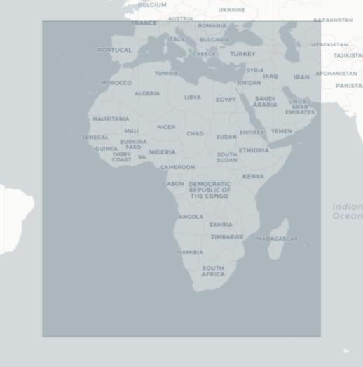
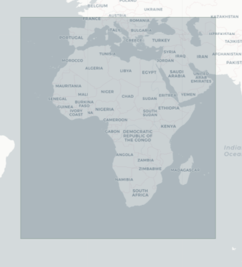
Figure 2 : Étendue géographique des dérivés SRTM DEM
Mesures
Tableau 2 : Mesures du produit SRTM DEM et des dérivés SRTM DEM
Nom du produit |
ID de la bande |
Description |
Unités |
Type de données |
Aucune donnée\(^\dagger\) |
|---|---|---|---|---|---|
|
élévation |
Données d’élévation. |
mètre |
|
|
|
mrvbf |
Planéité du fond de vallée multi-résolution (MrVBF) : cela permet d’identifier les fonds de vallée (zones de dépôt). Les valeurs zéro indiquent un terrain érodé et les valeurs ≥ 1 indiquent des zones de dépôt progressivement plus grandes. |
|
|
|
mrrtf |
Planéité du sommet des crêtes multi-résolution (MrRTF) : complémentaire de MrVBF, les valeurs zéro indiquent les zones escarpées ou basses, et les valeurs ≥ 1 indiquent des zones progressivement plus grandes de terrain plat et élevé. |
|
|
|
|
slope_30m |
Slope (percent): The rate of elevation change representing fine-scale variation in terrain gradients. Derived using a \(3 \times 3\) moving window |
|
|
|
|
slope_270m |
Slope (percent): this is the rate of elevation change derived from a DEM smoothed using a \(9 \times 9\) moving window (~270 m). It represents generalized terrain gradients by reducing local variability and highlighting broader landform inclination. |
|
|
|
|
tpi_90m |
Topographic Position Index (TPI): this represents the difference between the elevation of a pixel and the mean elevation of its \(3 \times 3\) surrounding neighbourhood (~90 m). Positive values indicate areas higher than their immediate surroundings (ridges), while negative values indicate areas lower than their surroundings (depressions), representing terrain position at a local scale. |
|
|
|
|
tpi_270m |
Topographic Position Index (TPI): this represents the difference between the elevation of a pixel and the mean elevation of its \(9 \times 9\) surrounding neighbourhood (~270 m). Positive values indicate areas higher than their surroundings (ridges), while negative values indicate areas lower than their surroundings (valleys), representing terrain position within the broader landscape. |
|
|
|
\(^\dagger\) Aucune donnée ni valeur de remplissage.
Traitement
Le MNT SRTM de la NASA version 3.0 est un ensemble de données à remplissage vide. Les données manquantes dans le MNT SRTM de la version 2.0 de la National Geospatial-Intelligence Agency (NGA) ont été remplies à l’aide de données topographiques provenant de sources non SRTM. Les données d’élévation de remplissage primaires provenaient du modèle d’élévation numérique mondial d’émission et de réflexion spatiales avancées de Terra (ASTER) Version 2.0 (GDEM2) et les données d’élévation de remplissage secondaires du modèle d’élévation USGS Global Multi-resolution Terrain Elevation Data (GMTED2010) ou du jeu de données d’élévation national USGS (NED). Les étapes de traitement de la version 3.0 de SRTM sont détaillées dans le « Guide de l’utilisateur de la collection Shuttle Radar Topography Mission (SRTM) <https://lpdaac.usgs.gov/documents/179/SRTM_User_Guide_V3.pdf> ».
The SRTM DEM Derivatives were generated by Digital Earth Africa from the SRTM v3.0 Digital Elevation Model. Slope and Topographic Position Index (TPI) were generated using gdaldem and additional moving window operations. Multi-resolution valley bottom flatness (MrVBF) and multi-resolution ridge top flatness (MrRTF) were derived using the SAGA GIS tool (Version: 2.3.1).
At the native resolution, both slope and TPI are computed using a \(3 \times 3\) neighbourhood. For slope, this represents the terrain gradient at the pixel scale (~30 m), as the window is used to estimate a local derivative at the centre pixel. For TPI, the same \(3 \times 3\) neighbourhood defines the surrounding area against which the pixel is compared, resulting in a spatial support of approximately 90 m.
Broader-scale derivatives were generated using a \(9 \times 9\) moving window (~270 m). For slope, this was achieved by first smoothing the DEM using a \(9 \times 9\) moving window mean filter and then computing slope, resulting in a generalized representation of terrain gradients that reduces local variability. For TPI, the \(9 \times 9\) neighbourhood was used directly to compute the mean surrounding elevation, providing a measure of terrain position relative to the broader landscape.
The scripts used to generate the derivatives are available here.
Médias et exemples d’images
Figure 3 : Données d’élévation SRTM DEM pour le mont Kenya
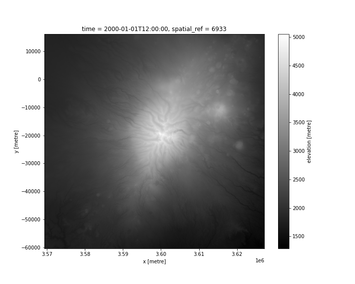
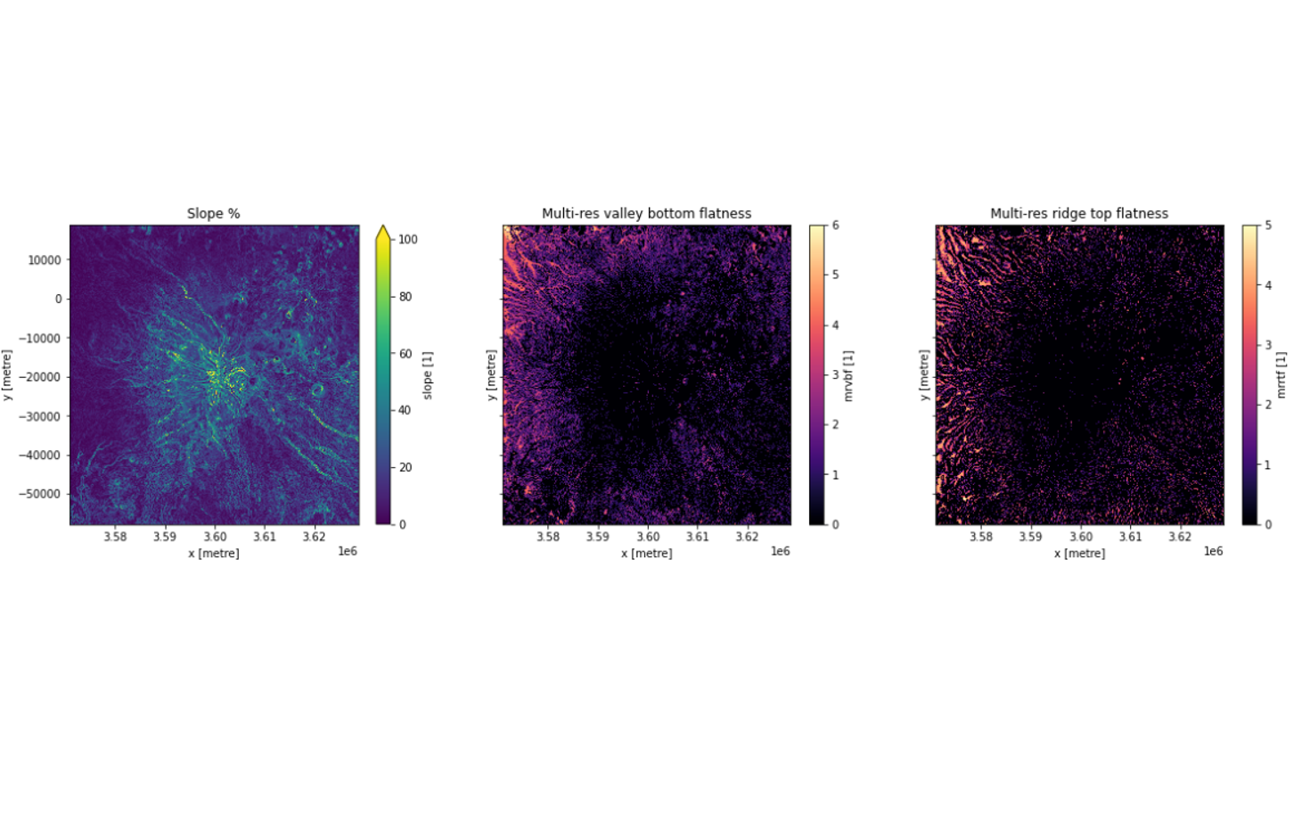
Figure 4 : Dérivés SRTM DEM pour le mont Kenya
Références
G., Rosen, P. A., Caro, E., Crippen, R., Duren, R., Hensley, S., Kobrick, M., Paller, M., Rodriguez, E., Roth, L., Seal, D., Shaffer, S., Shimada, J., Umland, J., Werner, M., Oskin, M., Burbank, D., & Alsdorf, D. (2007). La mission de topographie radar de la navette. Dans Reviews of Geophysics (Vol. 45, numéro 2). American Geophysical Union (AGU). https://doi.org/10.1029/2005rg000183
Guide rapide de la mission de topographie radar de la navette (SRTM)
Catalogue de données LPDAAC <https://lpdaac.usgs.gov/products/srtmagl1v003/>`__
Licence et Remerciements
Le DEM SRTM est disponible sous une licence CC-BY-4.0.
Le produit Digital Earth Africa SRTM DEM Derivatives est fourni gratuitement, sous une licence Apache License 2.0.
Accès aux données
Services Web Amazon S3
Le SRTM DEM et les dérivés SRTM DEM sont disponibles dans AWS S3.
Tableau 3 : Détails d’accès aux données AWS SRTM DEM et SRTM DEM Derivatives
Détails AWS S3 |
||
|---|---|---|
Produit |
SRTM DEM |
Dérivés SRTM DEM |
Seau ARD |
|
|
Région |
|
|
Le bucket se trouve dans la région AWS « af-south-1 » (Le Cap). Des spécifications de région supplémentaires peuvent être appliquées comme suit :
aws s3 ls --region=af-sud-1 s3://deafrica-input-datasets/
Le chemin d’accès au fichier SRTM DEM est : « strm_dem/dem_srtm ». Le chemin d’accès au fichier SRTM Derivatives est : « srtm_dem/dem_srtm_deriv ».
Services Web OGC (OWS)
Le SRTM DEM et les dérivés SRTM DEM sont disponibles via l’OWS de DE Africa.
Tableau 5 : Détails d’accès aux données OWS.
Détails de l’OWS |
|
|---|---|
Nom |
« DE Africa Services » |
URL des services de cartographie Web (WMS) |
|
URL du service de couverture Web (WCS) |
|
Noms des calques |
|
Les détails de Digital Earth Africa OWS peuvent être trouvés sur https://ows.digitalearth.africa/.
Pour obtenir des instructions sur la façon de se connecter à OWS, consultez ce tutoriel.
Open Data Cube (ODC)
Le SRTM DEM et les dérivés SRTM DEM sont accessibles via l’API ODC de Digital Earth Africa, qui est disponible via le « Digital Earth Africa Sandbox <https://sandbox.digitalearth.africa/hub/login> »__.
Noms de produits ODC : dem_srtm, dem_srtm_deriv
Des bandes de données spécifiques peuvent être appelées en utilisant soit les noms par défaut, soit l’un des noms alternatifs d’une bande, comme indiqué dans le tableau ci-dessous. Les commandes ODC Datacube.load sans bandes spécifiées chargeront toutes les bandes.
Tableau 6 : noms de bandes des produits ODC dem_srtm et dem_srtm_deriv
Produit |
Nom du groupe |
Noms alternatifs |
Remplir la valeur |
|---|---|---|---|
|
élévation |
NaN |
|
|
mrvbf |
NaN |
|
mrrtf |
NaN |
|
|
slope_30m |
NaN |
|
|
slope_270m |
NaN |
|
|
tpi_90m |
NaN |
|
|
tpi_270m |
NaN |
|
Informations techniques
La méthode de levé géodésique de terrain du système de positionnement global cinématique a été utilisée pour valider les données SRTM. Environ 70 000 kilomètres de lignes de levé ont été collectées. Les données ont été utilisées pour modéliser les sources d’erreurs à grande longueur d’onde. De plus, le JPL de la NASA a déployé des réflecteurs d’angle pendant la mission SRTM, qui ont été déployés avec des coordonnées mesurées avec précision et ont servi de points de contrôle dans les données SRTM.
Les problèmes connus dans le SRTM de la NASA sont décrits dans la publication suivante :
Rodriguez, E., C. S. Morris et J. E. Belz (2006), Une évaluation globale des performances du SRTM, Photogramm. Eng. Remote Sens., 72, 249–260. https://doi.org/10.14358/PERS.72.3.249.