Littoraux
Produits utilisés : DE Africa Coastlines
Mots-clés : données utilisées ; littoraux
Aperçu
Le littoral africain, long et dynamique, est soumis à de nombreuses pressions, notamment des conditions météorologiques et climatiques extrêmes, l’élévation du niveau de la mer et le développement humain. Il est essentiel de comprendre comment le littoral réagit à ces pressions pour gérer cette région, d’un point de vue social, environnemental et économique.
Le « Digital Earth Africa Coastlines <https://docs.digitalearthafrica.org/en/latest/data_specs/Coastlines_specs.html> »__ est un ensemble de données continentales qui comprend les littoraux annuels et les taux de changement côtier le long de l’ensemble du littoral africain de 2000 à 2021.
Le produit combine les données satellite du programme Digital Earth Africa avec la modélisation des marées pour cartographier l’emplacement typique du littoral au niveau moyen de la mer pour chaque année. Le produit permet d’examiner chaque année les tendances de l’érosion et de la croissance côtières à l’échelle locale et continentale, et de cartographier les modèles de changement côtier de manière historique et de les mettre à jour régulièrement à mesure que les données continuent d’être acquises. Cela permet de comparer les taux actuels de changement côtier à ceux observés au cours des années ou des décennies précédentes.
La possibilité de cartographier les positions du littoral pour chaque année fournit des informations précieuses sur la question de savoir si les changements du littoral sont le résultat d’événements ou d’actions particuliers ou d’un processus de changement plus progressif au fil du temps. Ces informations peuvent permettre aux scientifiques, aux gestionnaires et aux décideurs politiques d’évaluer les impacts de l’ensemble des facteurs qui affectent le littoral et éventuellement d’aider à la planification et à la prévision des scénarios futurs.
Applications
Suivi et cartographie des taux d’érosion côtière le long du littoral africain
Prioriser et évaluer les impacts de la gestion côtière locale et régionale en fonction de l’évolution historique du littoral
Modélisation de la façon dont les littoraux réagissent aux facteurs de changement, notamment les phénomènes météorologiques extrêmes, l’élévation du niveau de la mer ou le développement humain
Soutenir les études géomorphologiques sur la manière dont et pourquoi les littoraux ont changé au fil du temps
Pour une description complète des spécifications du produit, des résultats de validation et des méthodes utilisées pour développer les produits, consultez le document « Spécifications DE Africa Coastlines <https://docs.digitalearthafrica.org/en/latest/data_specs/Coastlines_specs.html> ».
Description
Ce bloc-notes montrera comment charger, tracer et effectuer une analyse simple à l’aide du produit Digital Earth Africa Coastlines.
Les sujets abordés comprennent :
Chargement des données annuelles du littoral DE Africa Coastlines à l’aide de la fonction « get_coastlines ».
Chargement des données statistiques sur les taux de changement des côtes de l’Afrique de l’Ouest à l’aide de la fonction « get_coastlines ».
Extraction de données de littoral pour un ou plusieurs transects côtiers à l’aide d’une application interactive DE Africa Coastlines.
Commencer
Pour exécuter cette analyse, exécutez toutes les cellules du bloc-notes, en commençant par la cellule « Charger les packages ».
Charger des paquets
Importez les packages Python utilisés pour l’analyse.
[1]:
import geopandas as gpd
import matplotlib.pyplot as plt

from deafrica_tools.coastal import get_coastlines
from deafrica_tools.app import deacoastlines
from deafrica_tools.plotting import display_map
Paramètres d’analyse
Cette section définit les paramètres d’analyse, notamment :
central_lat, central_lon, buffer: latitude/longitude centrales et taille de la fenêtre d’analyse pour la zone d’intérêt
L’emplacement par défaut est une zone sur la plage de Nyali le long de la côte kenyane.
[2]:
# Set the central latitude and longitude.
central_lat = -4.049068
central_lon = 39.708946

# Set the buffer to load around the central coordinates.
buffer = 0.03

# Compute the bounding box for the study area.
xmin, xmax = central_lon - buffer, central_lon + buffer
ymin, ymax = central_lat - buffer, central_lat + buffer
bbox = (xmin, ymin, xmax, ymax)
Afficher l’emplacement sélectionné
La cellule suivante affichera la zone sélectionnée sur une carte interactive. N’hésitez pas à zoomer et dézoomer pour mieux comprendre la zone que vous allez analyser. En cliquant sur n’importe quel point de la carte, vous découvrirez les coordonnées de latitude et de longitude de ce point.
[3]:
display_map(x=(xmin, xmax), y=(ymin, ymax))
[3]:
Chargement des données sur les côtes de l’Afrique de l’Ouest
Rivages annuels
Les données DE Africa Coastlines peuvent être chargées directement dans un script Python ou un bloc-notes Jupyter à l’aide de la fonction get_coastlines. Cette fonction utilise le service Web de fonctionnalités DE Africa Coastlines (WFS) et geopandaspour charger les données DE Africa Coastlines pour une zone de délimitation fournie.
[4]:
# Load DE Africa Coastlines annual shorelines data.
deacl_shorelines_gdf = get_coastlines(bbox=bbox,
                                      layer='shorelines')

# Print example output.
deacl_shorelines_gdf.head()
[4]:
| id | year | certainty | tide_datum | country | geometry | |
|---|---|---|---|---|---|---|
| 28 | coastlines_v0_4_2_shorelines_annual.8670 | 2022 | good | 0 m AMSL | Kenya | MULTILINESTRING ((39.68128 -4.05546, 39.68144 ... |
| 14 | coastlines_v0_4_2_shorelines_annual.8654 | 2012 | good | 0 m AMSL | Kenya | MULTILINESTRING ((39.68133 -4.05546, 39.68144 ... |
| 26 | coastlines_v0_4_2_shorelines_annual.8668 | 2021 | good | 0 m AMSL | Kenya | MULTILINESTRING ((39.68135 -4.05546, 39.68144 ... |
| 20 | coastlines_v0_4_2_shorelines_annual.8661 | 2017 | good | 0 m AMSL | Kenya | MULTILINESTRING ((39.68132 -4.05546, 39.68144 ... |
| 22 | coastlines_v0_4_2_shorelines_annual.8664 | 2019 | good | 0 m AMSL | Kenya | MULTILINESTRING ((39.68131 -4.05546, 39.68144 ... |
Nous pouvons désormais tracer les données annuelles du littoral des côtes de l’Afrique de l’Est à l’aide de « géopandas ». Effectuez un zoom sur Nyali Beach au Kenya sur la carte interactive pour afficher les données du littoral.
Les lignes de rivage annuelles représentent la position médiane ou « la plus représentative » du rivage à environ la marée moyenne du niveau de la mer (0 m au-dessus du niveau moyen de la mer) pour chaque année à partir de 2000. Les lignes de couleur claire (par exemple jaune) dans le graphique ci-dessous représentent les rivages récents (par exemple 2020), tandis que les lignes de couleur foncée représentent les rivages plus anciens (par exemple 2000).
Remarque : pour plus de détails sur les données annuelles sur le littoral de DE Africa Coastlines, reportez-vous à la description officielle du produit Digital Earth Africa Coastlines <https://docs.digitalearthafrica.org/en/latest/data_specs/Coastlines_specs.html>`__.
[5]:
# Plot on interactive map of DE Africa Coastlines data within our bounding box.
deacl_shorelines_gdf.explore(column='year', cmap='inferno', categorical=True)
[5]:
Points statistiques sur les taux de variation
Nous pouvons également charger et tracer les points statistiques de taux de changement des côtes de l’Afrique de l’Est. Ces points fournissent des taux robustes de changement côtier annuel (en mètres par an) pour chaque 30 m le long des côtes non rocheuses (par exemple sablonneuses et boueuses) de l’Afrique. Ces taux sont calculés en régressant linéairement les positions annuelles du littoral en fonction du temps, en utilisant le littoral le plus récent comme base de référence.
Les valeurs négatives (points rouges) indiquent un recul (par exemple, l’érosion) et les valeurs positives indiquent une croissance (par exemple, la progradation) au fil du temps. Par défaut, les taux de changement sont affichés pour les points présentant une tendance statistiquement significative au fil du temps uniquement.
Remarque : pour plus de détails sur les données statistiques sur les taux de changement des côtes de l’Afrique de l’Est, reportez-vous à la description officielle du produit « Digital Earth Africa Coastlines » <https://docs.digitalearthafrica.org/en/latest/data_specs/Coastlines_specs.html>.
[6]:
# Load DE Africa Coastlines annual shorelines data within our bounding box.
deacl_statistics_gdf = get_coastlines(bbox=(xmin, ymin, xmax, ymax),
                                      layer='statistics')

# Filter points to statistically significant results only.
deacl_statistics_gdf = deacl_statistics_gdf.loc[
    deacl_statistics_gdf.sig_time < 0.01]

# Plot on interactive map.
deacl_statistics_gdf.explore(column='rate_time',
                             cmap='RdBu',
                             vmin=-3,
                             vmax=3,
                             tooltip='rate_time')
[6]:
Les points de données statistiques sur les taux de changement des côtes de l’Afrique de l’Est fournissent également de nombreuses statistiques supplémentaires qui donnent un aperçu des changements côtiers en Afrique. Pour une description complète de chacune de ces statistiques, reportez-vous à la section Statistiques sur les taux de changement de la description officielle du produit « Digital Earth Africa Coastlines <https://docs.digitalearthafrica.org/en/latest/data_specs/Coastlines_specs.html> »__.
[7]:
deacl_statistics_gdf.head()
[7]:
| id | uid | rate_time | sig_time | se_time | outl_time | dist_2000 | dist_2001 | dist_2002 | dist_2003 | ... | angle_std | valid_obs | valid_span | sce | nsm | max_year | min_year | certainty | country | geometry | |
|---|---|---|---|---|---|---|---|---|---|---|---|---|---|---|---|---|---|---|---|---|---|
| 297 | coastlines_v0_4_2_rates_of_change.325533 | None | 0.29 | 0.005 | 0.09 | -8.34 | -12.22 | -15.24 | -8.25 | ... | 6 | 24 | 24 | 15.24 | 8.34 | 2023 | 2002 | good | Kenya | POINT (39.67907 -4.07373) | |
| 298 | coastlines_v0_4_2_rates_of_change.325534 | None | 0.29 | 0.005 | 0.09 | -8.15 | -13.77 | -16.64 | -11.88 | ... | 9 | 24 | 24 | 16.64 | 8.15 | 2023 | 2002 | good | Kenya | POINT (39.67933 -4.07369) | |
| 299 | coastlines_v0_4_2_rates_of_change.325535 | None | 0.24 | 0.005 | 0.08 | -6.28 | -9.53 | -10.46 | -8.78 | ... | 11 | 24 | 24 | 12.36 | 6.28 | 2023 | 2007 | good | Kenya | POINT (39.67948 -4.07348) | |
| 300 | coastlines_v0_4_2_rates_of_change.325536 | None | 0.21 | 0.007 | 0.07 | -7.15 | -8.24 | -7.94 | -7.01 | ... | 11 | 24 | 24 | 10.89 | 7.15 | 2023 | 2015 | good | Kenya | POINT (39.6796 -4.07324) | |
| 302 | coastlines_v0_4_2_rates_of_change.325538 | None | 0.37 | 0.001 | 0.10 | -11.01 | -15.63 | -17.42 | -12.57 | ... | 7 | 24 | 24 | 17.42 | 11.01 | 2023 | 2002 | good | Kenya | POINT (39.68 -4.07295) |
5 rows × 41 columns
Exportation des données côtières de l’Afrique de l’Ouest sous forme de fichiers vectoriels
Nous pouvons facilement exporter les données chargées sous forme de fichiers vectoriels spatiaux (par exemple, ESRI Shapefiles ou GeoJSON) afin qu’elles puissent être analysées plus en détail dans un logiciel SIG :
[8]:
deacl_shorelines_gdf.to_file('deacoastlines_shorelines.shp')
deacl_statistics_gdf.to_file('deacoastlines_statistics.shp')
Outils d’analyse des côtes de l’Afrique de l’Ouest
Les sections suivantes fournissent des outils utiles pour analyser les données des côtes de l’Afrique de l’Est directement dans un bloc-notes Jupyter sans avoir à charger les données dans un logiciel SIG. Toutes les sorties des outils ci-dessous seront enregistrées dans un nouveau dossier de ce répertoire appelé « deacoastlines_outputs ».
Extraire les données du littoral par transect côtier
L’outil « deacoastlines.transect_app » vous permet de dessiner de manière interactive un transect sur les données annuelles du littoral de DE Africa Coastlines et d’obtenir un graphique montrant comment les positions du littoral ont changé au fil du temps. Pour utiliser l’outil :
Exécutez la cellule ci-dessous ; une application interactive apparaîtra
Effectuez un zoom avant sur la carte et utilisez l’outil « Dessiner une polyligne » à gauche pour dessiner un transect de manière à ce qu’il traverse un ensemble de rivages (voir l’exemple ci-dessous). Les transects doivent être dessinés dans une direction cohérente, par exemple en commençant sur terre et en terminant sur l’eau. Cela permet de comparer les résultats entre les transects.
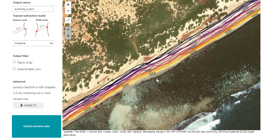
Appuyez sur « Terminer » lorsque vous êtes satisfait de la ligne, puis cliquez sur le bouton « Extraire les données du rivage » en bas à gauche.
Un graphique apparaîtra sous la carte indiquant les distances le long du transect jusqu’à chaque rivage annuel (les distances seront mesurées à partir du début de la ligne de transect que vous avez tracée ci-dessus)
Facultatif : définissez le mode d’extraction de transaction sur « largeur » et réexécutez la cellule ci-dessous pour mesurer la largeur entre deux ensembles adjacents de côtes (par exemple à travers le col d’un tombolo ou d’un banc de sable).
Facultatif : téléchargez un fichier GeoJSON ou ESRI Shapefile contenant des transects à l’aide du bouton « Télécharger » pour extraire automatiquement les positions du littoral à partir de plusieurs transects côtiers (les fichiers téléchargés doivent avoir une taille inférieure à 5 mégaoctets).
[9]:
deacoastlines.transect_app()
[9]:
La figure obtenue montre comment les rivages à cet endroit ont changé au fil du temps.
En mode « distance », l’axe des Y indique la distance entre le début du transect et l’endroit où le transect croise chaque ligne de côte annuelle (indiquée sur l’axe des X). Si les transects ont été tracés avec un point de départ sur terre, des distances décroissantes au fil du temps indiquent que le littoral à cet endroit reculait ou s’érodait depuis 2000. Inversement, des distances croissantes au fil du temps indiquent que le littoral s’étendait.
En mode « largeur », l’axe des Y indique la distance (c’est-à-dire la largeur) entre la première et la dernière fois que le transect croise chaque ligne de rivage annuelle. Des largeurs croissantes indiquent qu’un banc de sable, une flèche ou une péninsule s’est élargi au fil du temps ; des largeurs décroissantes indiquent qu’il s’est érodé ou s’est rétréci.
Prochaines étapes : carnet de bord sur l’érosion du littoral
Le carnet d’érosion côtière « Coastal erosion notebook <../Real_world_examples/Coastal_erosion.ipynb> » de ce référentiel fournit un exemple simplifié de la méthode utilisée pour extraire les données annuelles du littoral de DE Africa Coastlines. Exécutez ce carnet si vous souhaitez générer des littoraux plus personnalisés pour un emplacement, une période, une époque (par exemple, des littoraux annuels ou bisannuels) ou une amplitude de marée (par exemple, la position du littoral à marée basse, moyenne ou haute).
Remarque : ce bloc-notes prend actuellement en charge l’extraction des données côtières uniquement, sans générer de statistiques sur les taux de changement comme celles incluses dans le produit DE Africa Coastlines.
Informations Complémentaires
Licence : Le code de ce carnet est sous licence Apache, version 2.0 <https://www.apache.org/licenses/LICENSE-2.0>. Les données de Digital Earth Africa sont sous licence Creative Commons par attribution 4.0 <https://creativecommons.org/licenses/by/4.0/>.
Contact : Si vous avez besoin d’aide, veuillez poster une question sur le canal Slack Open Data Cube <http://slack.opendatacube.org/>`__ ou sur le GIS Stack Exchange en utilisant la balise open-data-cube (vous pouvez consulter les questions posées précédemment ici). Si vous souhaitez signaler un problème avec ce bloc-notes, vous pouvez en déposer un sur Github.
Version de Datacube compatible :
[10]:
import datacube
print(datacube.__version__)
1.8.20
Dernier test :
[11]:
from datetime import datetime
datetime.today().strftime('%Y-%m-%d')
[11]:
'2025-01-15'