Copernicus Global Land Service - Lake Water Quality
Date modified: 23 July 2025
Overview
Aperçu
The Copernicus Global Land Service – Lake Water Quality products offer a comprehensive, satellite-derived monitoring system for assessing key water quality indicators in major large lakes, typically those greater than 50 hectares. These datasets are generated using optical satellite sensors, primarily Sentinel-2 MSI and Sentinel-3 OLCI, with earlier archives derived from Envisat MERIS. Spanning multiple spatial resolutions (100 m and 300 m) and temporal scales (10-day composites), they support both near-real-time and retrospective assessments of inland water quality.
Key parameters include surface reflectance, turbidity, total suspended matter (TSM), chlorophyll-a concentration, trophic state index, and floating cyanobacteria risk—all essential for monitoring eutrophication, ecological health, and harmful algal blooms (HABs). The datasets cover the period from 2002 to the present, providing long-term continuity for environmental monitoring and scientific research, with focused coverage in Europe and Africa.
All products are delivered using standardized geospatial grids (EPSG:4326) and include quality flags, detailed metadata, and validation against in situ observations to ensure reliability. Continuous improvements across product versions—such as enhanced atmospheric correction and updated retrieval algorithms—have significantly improved accuracy and usability. In addition, comprehensive user manuals, technical documentation, and support materials are available, making the data highly accessible to researchers, policymakers, and environmental managers.
Digital Earth Africa (DE Africa) hosts these datasets for the African region, providing free and open access to both the data and associated tools through the DE Africa Sandbox. Below are the Copernicus Global Land Service - Lake Water Quality products available via DE Africa.
Lake Water Quality 2019-2024 (raster 100 m), 10-daily – version 1
The dataset provides high-resolution composites of key lake water quality parameters—such as turbidity, trophic state index, and surface reflectance—derived from Sentinel-2 MSI observations. Covering the period from 2019 to 2024, it offers data with a focus on Africa, updated within four days after each dekad. This version is designed for retrospective environmental monitoring and supports long-term assessment of lake ecosystem health and water clarity trends. For more details, general information is available here, and the Product Manual provides comprehensive technical guidance.
Lake Water Quality 2024 - present (raster 100 m), 10-daily – version 2
This is a high-resolution Earth observation dataset designed to monitor the ecological status of inland water bodies. Based on Sentinel-2 MSI imagery, it provides 10-day composites of key lake water quality parameters—including turbidity, chlorophyll‑a concentration, total suspended matter, and cyanobacteria risk—at a 100 m spatial resolution. This second version introduces improved atmospheric correction, direct retrieval of turbidity from water-leaving reflectance, and additional quality flags to enhance the reliability of observations. With near-real-time updates available within three days after each dekad, the dataset supports environmental monitoring, water resource management, and early warning systems for water-related hazards across diverse lake systems. For more details, general information is available here, and the Product Manual provides comprehensive technical guidance.
Lake Water Quality 2002-2012 (raster 300 m), 10-daily – version 1
This dataset provides 10-day composites of water quality parameters—such as turbidity, trophic state index, and surface reflectance—at 300 m resolution for lakes. Based on MERIS satellite observations, it supports historical analysis of lake ecosystem health and water clarity. The archive is especially valuable for long-term monitoring and retrospective studies of medium to large lakes worldwide. For more details, general information is available here, and the Product Manual provides comprehensive technical guidance.
Lake Water Quality 2016-2024 (raster 300 m), 10-daily – version 1
This product delivers 10-day composites of key lake water quality parameters—including turbidity, trophic state index, and surface reflectance—on a 300 m grid derived from Sentinel‑3 OLCI data. Available from April 30, 2016, through October 2024, it provides near-real-time updates within three days after each dekad and covers medium to large lakes worldwide. Designed for monitoring ecosystem health and water clarity trends, it supports applications in environmental management, research, and water quality assessment. For more details, general information is available here, and the Product Manual provides comprehensive technical guidance.
Lake Water Quality 2024 - present (raster 300 m), 10-daily – version 2
The Lake Water Quality 2024–present dataset provides 10-day composites of key water quality parameters at 300 m resolution, derived from Sentinel-3 OLCI observations. Version 2 enhances the dataset by introducing additional indicators such as chlorophyll‑a, total suspended matter, cyanobacteria risk, and associated quality metrics. It supports real-time monitoring of freshwater ecosystems and is updated within three days of each dekad, enabling timely assessment of water clarity and biological activity in lakes worldwide. For more details, general information is available here, and the Product Manual provides comprehensive technical guidance.
Spécifications
Relevant coverage and metadata for each of the datasets can be viewed on DE Africa Metadata Explorer:
Lake Water Quality 2019-2024 (raster 100 m), 10-daily – version 1
Lake Water Quality 2024 - present (raster 100 m), 10-daily – version 2
Lake Water Quality 2002-2012 (raster 300 m), 10-daily – version 1
Lake Water Quality 2016-2024 (raster 300 m), 10-daily – version 1
Lake Water Quality 2024 - present (raster 300 m), 10-daily – version 2
A Jupyter Notebook which demonstrates loading and using loading the products in the Sandbox is also available.
Lake Water Quality Products
Caractéristiques
Table 1: 100m Products
Spécification |
LWQ 2019–2024 (100 m) v1 |
LWQ 2024–present (100 m) v2 |
|---|---|---|
Cell size (metres) |
100 x 100 |
100 x 100 |
Coordinate Reference System |
EPSG:4326 (WGS 84) |
EPSG:4326 (WGS 84) |
Résolution temporelle |
10 days |
10 days |
Plage temporelle |
2019–2024 |
2024–present (NRT) |
Version |
1 |
2 |
Ensemble de données parent |
Sentinel-2 MSI, Sentinel-3 OLCI |
Sentinel-2 MSI, Sentinel-3 OLCI |
Fréquence de mise à jour |
10-daily composites |
10-daily composites (Near real-time) |
Access |
Free and open via DE Africa |
Free and open via DE Africa |
Table 2: 300m Products
Spécification |
LWQ 2002–2012 (300 m) v1 |
LWQ 2016–2024 (300 m) v1 |
LWQ 2024–present (300 m) v2 |
|---|---|---|---|
Cell size (metres) |
300 x 300 |
300 x 300 |
300 x 300 |
Coordinate Reference System |
EPSG:4326 (WGS 84) |
EPSG:4326 (WGS 84) |
EPSG:4326 (WGS 84) |
Résolution temporelle |
10 days |
10 days |
10 days |
Plage temporelle |
2002–2012 |
2016–2024 |
2024–present (NRT) |
Version |
1 |
1 |
2 |
Ensemble de données parent |
Envisat MERIS |
Sentinel-3 OLCI, Envisat MERIS |
Sentinel-3 OLCI |
Fréquence de mise à jour |
10-daily composites |
10-daily composites |
10-daily composites (Near real-time) |
Access |
Free and open via DE Africa |
Free and open via DE Africa |
Free and open via DE Africa |
Measurements
Table 3: 100m Products
Measurement |
LWQ 2019–2024 (100 m) v1 |
LWQ 2024–present (100 m) v2 |
|---|---|---|
Turbidity |
Yes |
Yes |
Trophic State Index |
Yes |
Yes |
Surface Reflectance |
Yes |
Yes |
Chlorophyll-a |
No |
Yes |
Total Suspended Matter (TSM) |
No |
Yes |
Cyanobacteria Risk |
No |
Yes |
Quality Flags |
No |
Yes |
Table 4: 300m Products
Measurement |
LWQ 2002–2012 (300 m) v1 |
LWQ 2016–2024 (300 m) v1 |
LWQ 2024–present (300 m) v2 |
|---|---|---|---|
Turbidity |
Yes |
Yes |
Yes |
Trophic State Index |
Yes |
Yes |
Yes |
Surface Reflectance |
Yes |
Yes |
Yes |
Chlorophyll-a |
No |
No |
Yes |
Total Suspended Matter (TSM) |
No |
No |
Yes |
Cyanobacteria Risk |
No |
No |
Yes |
Quality Flags |
No |
No |
Yes |
Geographic Extent
All products in the Copernicus Lake Water Quality collection share the same geographic extent, as illustrated in Figure 1; data are available for the regions shaded in blue. Specific temporal and geographic extents for each product can be explored interactively using the Digital Earth Africa Metadata Explorer. Different Lake Water Quality products can be selected from the horizontal dropdown menu at the top of the page.
Figure 1: Copernicus Lake Water Quality geographic extent

Traitement
The complete processing methodology for these products is detailed in the Technical Manual.
Médias et exemples d’images
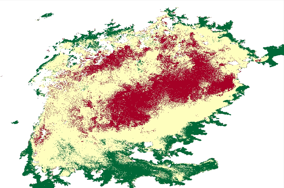
Image 1: CGLS – Lake Water Quality 2016-2024 (raster 300 m) - version 1
Turbidity is a measure of water clarity. In the image below of Lake Victoria—located at the border of Uganda, Kenya, and Tanzania—red indicates areas with higher turbidity, meaning the water is less clear and more turbid, while green represents lower turbidity values, indicating clearer water.

Image 2: CGLS – Lake Water Quality 2024 - present (raster 300 m) – version 2
In the image below, colors represent the percentage values of the Trophic State Index (TSI) in the water, with red indicating higher percentages and green indicating lower percentages. Lake Victoria, shown here, is situated at the intersection of Uganda, Kenya, and Tanzania on the African continent.
Licence
Licence internationale CC BY Attribution 4.0
Remerciements
The Copernicus Global Land Service - Lake Water Quality products were produced by the European Commission, Joint Research Centre (JRC), and are freely provided via the Copernicus Land Monitoring Service. Data access and regional support were enabled by Digital Earth Africa.
Accès aux données
Amazon Web Services S3
The Digital Earth Africa Copernicus Global Land Service Lake Water Quality products can be accessed from the associated S3 bucket.
Tableau 5 : Détails de l’accès aux données AWS
Détails AWS S3 |
|
|---|---|
ARN du compartiment |
|
Noms de produits |
|
Le seau est situé dans la région « af-south-1 » (Le Cap)
Table 6: AWS file path convention
Élément de chemin de fichier |
Description |
Exemple |
|---|---|---|
« nom du produit » |
|
|
|
Version du produit |
« 1-0-0 » |
|
path number ranging from |
« 165 » |
|
row number ranging from |
« 052 » |
|
Année de collecte des données |
« 2019 » |
|
Mois de l’année où les données ont été collectées (avec des zéros non significatifs) |
« 03 » |
|
Jour du mois où les données ont été collectées (avec des zéros non significatifs) |
« 28 » |
Services Web OGC (OWS)
Ce produit est disponible via OWS de DE Africa.
Tableau 7 : Détails d’accès aux données OWS.
Détails de l’OWS |
|
|---|---|
Nom |
« DE Africa Services » |
URL des services de cartographie Web (WMS) |
|
URL du service de couverture Web (WCS) |
|
Noms des calques |
|
Les détails de Digital Earth Africa OWS peuvent être trouvés sur https://ows.digitalearth.africa/.
Pour obtenir des instructions sur la façon de se connecter à OWS, consultez « ce tutoriel <../web_services/index.ipynb> ».
Open Data Cube (ODC)
The Lake Water Quality collection can be accessed through the Digital Earth Africa ODC API, which is available through the Digital Earth Africa Sandbox.
ODC product name: cgls_lwq100_2019_2024, cgls_lwq100_2024_nrt, cgls_lwq300_2002_2012, cgls_lwq300_2016_2024, cgls_lwq300_2024_nrt