Copernicus DEM (COP-DEM)
Date modified: 09 May 2025
Product overview
Background
The Copernicus DEM is a Digital Surface Model (DSM) that represents the Earth’s surface. The Copernicus DEM is provided by the European Space Agency (ESA) in 3 different instances:
COP-DEM-EEA-10 : provides coverage of the European Economic Area (EEA) member states and the 6 cooperating countries at 0.3 arc seconds (~10m) spatial resolution
COP-DEM-GLO-30 : provides global coverage at 1.0 arc seconds (~30m) spatial resolution
COP-DEM-GLO-90 : provides global coverage at 3.0 arc second (~90m) spatial resolution
There are two instances of the COP-DEM-GLO-30 Copernicus DEM: COP-DEM-GLO-30-R and COP-DEM-GLO-30 Public. COP-DEM-GLO-30 Public provides limited worldwide coverage at 1.0 arc seconds (~30m) spatial resolution because a small subset of tiles covering specific countries are not yet released to the public by the Copernicus Programme. The list of countries presenting constraints in terms of access rights is available here. COP-DEM-GLO-30-R provides complete global coverage, but is only accessible to users belonging to the authorised users categories as defined in the applicable license.
Digital Earth Africa provides free and open access to a copy of the COP-DEM-GLO-30 Public and COP-DEM-GLO-90 products over Africa. For more information on these products see the Copernicus DEM website and Copernicus DEM Product Handbook.
A Jupyter Notebook which demonstrates loading and using DEM datasets in the Sandbox is also available.
Specifications
Spatial and temporal coverage
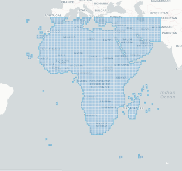
Relevant metadata for the COP-DEM-GLO-30 Public and COP-DEM-GLO-90 products as well as their temporal and geographic extents can be viewed on the interactive DE Africa Metadata Explorer here and here. Data is available for the regions shaded in blue.
Table 1: COP-DEM-GLO-30 Public and COP-DEM-GLO-90 product specifications
Specification |
||
|---|---|---|
Product name |
|
|
Cell size - X (arc seconds) |
1.0 (~30 m) |
3.0 (~90 m) |
Cell size - Y (arc seconds) |
1.0 (~30 m) |
3.0 (~90 m) |
Coordinate reference system |
EPSG: 4326 |
EPSG: 4326 |
Update frequency |
None, except if the public tile list changes. |
None |
Figure 1: COP-DEM-GLO-30 Public geographic extent
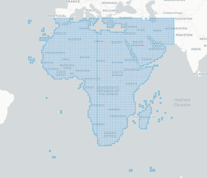
Figure 2: COP-DEM-GLO-90 geographic extent
Measurements
Table 2: COP-DEM-GLO-30 Public and COP-DEM-GLO-90 product measurements
Product name |
Band ID |
Description |
Units |
Data type |
No data value |
|---|---|---|---|---|---|
|
elevation |
Elevation data |
|
|
|
|
elevation |
Elevation data |
|
|
|
Processing
The Copernicus DEM is derived from an edited DSM named WorldDEM which was based on the radar satellite data acquired during the TanDEM-X Mission. For the edited WorldDEM, the flattening of water bodies and consistent flow of rivers has been included, and editing of shore- and coastlines, special features such as airports and implausible terrain structures has also been applied. The edited WorldDEM was also infilled on a local basis with the following DEMs: ASTER, SRTM90, SRTM30, SRTM30plus, GMTED2010, TerraSAR-X Radargrammetric DEM, ALOS World 3D-30m. The Copernicus DEM product generation and editing process is described in the Product Handbook.
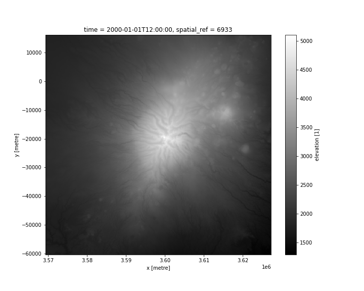
Media and example images
Figure 3: COP-DEM-GLO-30 Public elevation data for Mt. Kilimanjaro
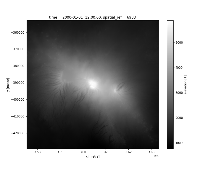
Figure 4: COP-DEM-GLO-90 elevation data for Mt. Kenya
References
License and Acknowledgements
The GLO-90 dataset is available worldwide with a free license. The GLO-30 dataset is available worldwide with a free license with the exception of two countries, reported in a dedicated list and available within the dataset COP-DEM_GLO-30-R. Full licences are available here.
Data Access
Amazon web services S3
The GLO-30 Public and GLO-90 instances of the Copernicus DEM are available in AWS S3 sponsored by the Public Dataset Program.
Table 3: Copernicus DEM GLO-30 Public and GLO-90 AWS data access details
AWS S3 details |
||
|---|---|---|
Product |
GLO-30 Public |
GLO-90 |
Bucket ARD |
|
|
Region |
|
|
The file paths follow the basic data formart: Copernicus_DSM_COG_[resolution]_[northing]_[easting]_DEM/ e.g. s3://copernicus-dem-90m/Copernicus_DSM_COG_30_S90_00_W178_00_DEM/
Table 4: AWS file path convention
File path element |
Description |
Example |
|---|---|---|
|
Resolution in arc seconds. |
|
|
This is the northing of the center of the bottom-most pixels in the original files. |
|
|
This is the easting of the center of the left-most pixels. |
|
OGC Web Services (OWS)
This GLO-30 Public and GLO-90 instances of the Copernicus DEM are available through DE Africa’s OWS.
Table 5: OWS data access details.
OWS details |
|
|---|---|
Name |
|
Web Map Services (WMS) URL |
|
Web Coverage Service (WCS) URL |
|
Layer names |
|
Digital Earth Africa OWS details can be found at https://ows.digitalearth.africa/.
For instructions on how to connect to OWS, see this tutorial.
Open Data Cube (ODC)
The GLO-30 Public and GLO-90 instances of the Copernicus DEM can be accessed through the Digital Earth Africa ODC API, which is available through the Digital Earth Africa Sandbox.
ODC product names: dem_cop_30, dem_cop_90
Specific bands of data can be called by using either the default names or any of a band’s alternative names, as listed in the table below. ODC Datacube.load commands without specified bands will load all bands.
Table 6: ODC products dem_cop_30 and dem_cop_90 band names
Product |
Band name |
Alternative names |
Fill value |
|---|---|---|---|
|
elevation |
NaN |
NaN |
|
elevation |
NaN |
NaN |
Technical information
The Copernicus DEM was validated using the Geoscience Laser Altimeter System (GLAS) of NASA’s Ice, Cloud and land Elevation Satellite (ICESat). The Global RMSE is 1.68 metres. The accuracy assessment is split into two parts, since the ice-covered regions have to be treated differently from the non-ice-covered regions, which are described in the Validation Report.