Utilisation du sol à l’échelle mondiale ESRI
Date de modification : 02 août 2022
Présentation du produit
Aperçu
La carte mondiale d’utilisation des terres et de couverture terrestre (LULC) d’ESRI à une résolution de 10 mètres a été développée par l”Impact Observatory (IO) avec l”Environmental Systems Research Institute (ESRI) et en partenariat avec Microsoft AI for Earth.
Digital Earth Africa offre un accès gratuit et ouvert à une copie du produit ESRI/IO Land Cover sur l’Afrique.
Un Jupyter Notebook qui démontre le chargement et l’utilisation des ensembles de données de couverture terrestre dans le Sandbox est également disponible.
Spécifications
Couverture spatiale et temporelle
Les métadonnées pertinentes pour le produit ESRI/IO Land Cover peuvent être consultées sur l’explorateur de métadonnées DE Africa <https://explorer.digitalearth.africa/products/io_lulc>`__.
Tableau 1 : Spécifications du produit ESRI/IO Land Cover
Spécification |
|
|---|---|
Nom du produit |
|
Taille de la cellule - X (degrés) |
0,0000898° (~10 m) |
Taille de la cellule - Y (degrés) |
0,0000898° (~10 m) |
Système de référence de coordonnées |
« Le produit n’a pas de CRS par défaut. » |
Résolution temporelle |
Annuel |
Plage temporelle |
2017 - 2021 |
Fréquence de mise à jour |
Annuel |
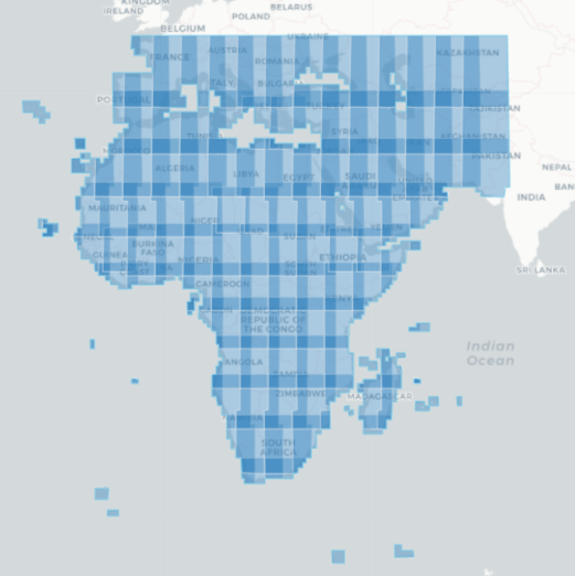
Les étendues temporelles et géographiques spécifiques du produit peuvent être explorées sous forme de carte interactive sur l’explorateur de métadonnées DE Africa <https://explorer.digitalearth.africa/products/io_lulc>. Les données sont disponibles pour la région ombrée en bleu.
Figure 1 : Étendue géographique du produit ESRI/IO Land Cover
Mesures
Tableau 2 : Mesures du produit ESRI/IO Land Cover
ID de la bande |
Description |
Unités |
Type de données |
Aucune donnée\(^\dagger\) |
|---|---|---|---|---|
données |
Classification de l’occupation du sol |
1 |
uint8 |
0 |
Traitement
La carte mondiale ESRI/IO LULC est dérivée de l’imagerie Sentinel-2 de l’Agence spatiale européenne (ESA). Un modèle de classification des terres par IA basé sur l’apprentissage profond a été formé à l’aide d’un ensemble de données de formation massif organisé par la National Geographic Society. Cet ensemble de données contient plus de 5 milliards de pixels d’imagerie Sentinel-2 étiquetés à la main, à partir de 6 bandes de données de réflectance de surface : bleu visible, vert, rouge, proche infrarouge et deux bandes infrarouges à ondes courtes. Les pixels ont été échantillonnés à partir de plus de 20 000 sites répartis dans tous les principaux biomes du monde.
Le modèle d’apprentissage profond UNET a été appliqué à plusieurs scènes Sentinel-2 de l’ESA sur une année, accessibles via l’ordinateur planétaire de Microsoft et mises à l’échelle à l’aide de Microsoft Azure Batch. Les images ont été classées en 9 classes distinctes d’utilisation/couverture du sol. Les prévisions LULC ont ensuite été composées pour générer une carte représentative de l’année.
La collection Esri 2020 Land Cover originale utilise 10 classes et une ancienne version du modèle d’apprentissage profond sous-jacent. Cette nouvelle carte utilise un modèle mis à jour du modèle à 10 classes et combine Grass (anciennement classe 3) et Scrub (anciennement classe 6) en une seule classe Rangeland (classe 11).
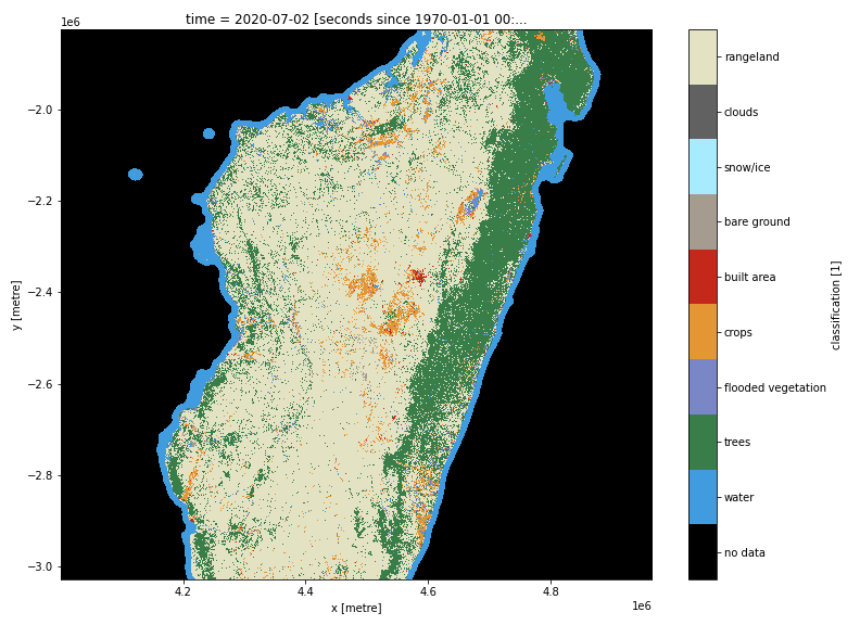
Médias et exemples d’images
Figure 2 : Classification de la couverture terrestre ESRI/IO pour Madagascar en 2020
Références
Karra, C. Kontgis, Z. Statman-Weil, J. C. Mazzariello, M. Mathis et S. P. Brumby, « Utilisation et couverture terrestre mondiales avec Sentinel 2 et l’apprentissage en profondeur », 2021 IEEE International Geoscience and Remote Sensing Symposium IGARSS, 2021, pp. 4704-4707, doi : 10.1109/IGARSS47720.2021.9553499.
Kontgis, C. (2021, 24 juin). « Cartographier le monde avec un niveau de détail sans précédent <https://caitlin-kontgis.medium.com/mapping-the-world-in-unprecedented-detail-7c0513205b90> »__
Licence et Remerciements
Ces données sont sous licence Creative Commons par attribution (CC BY 4.0).
Crédits : Impact Observatory, Microsoft et Esri
Accès aux données
Services Web OGC (OWS)
Le produit ESRI/IO Land Cover « io_lulc » est disponible via l’OWS de Digital Earth Africa.
Tableau 3 : Détails d’accès aux données OWS.
Détails de l’OWS |
|
|---|---|
Nom |
« DE Africa Services » |
URL des services de cartographie Web (WMS) |
|
URL du service de couverture Web (WCS) |
|
Nom de la couche |
|
Les détails de Digital Earth Africa OWS peuvent être trouvés sur https://ows.digitalearth.africa/.
Pour obtenir des instructions sur la façon de se connecter à OWS, consultez « ce tutoriel <../web_services/index.ipynb> ».
Open Data Cube (ODC)
Le produit ESRI/IO Land Cover est accessible via l’API ODC de Digital Earth Africa, qui est disponible via le « Digital Earth Africa Sandbox <https://sandbox.digitalearth.africa/hub/login> »__.
Nom du produit ODC : io_lulc
Le produit « io_lulc » ne possède qu’une seule bande de données spécifique qui peut être appelée en utilisant le nom par défaut, « data », ou par le nom alternatif de la bande, « classification », comme indiqué dans le tableau ci-dessous. Les commandes ODC « Datacube.load » sans bandes spécifiées chargeront la bande « data ».
Tableau 4 : noms de bandes io_lulc du produit ODC.
Nom du groupe |
Noms alternatifs |
Remplir la valeur |
|---|---|---|
données |
classification |
|
Informations techniques
Évaluation de la précision de la couverture terrestre ESRI 2020
La collection originale Esri 2020 Land Cover utilise 10 classes et une ancienne version du modèle d’apprentissage en profondeur sous-jacent.
Conformément aux meilleures pratiques en matière d’évaluation de la précision, Impact Observatory a ajusté les estimations de superficie pour chaque classe de couverture terrestre dans le produit ESRI 2020 Land Cover en utilisant la précision de son utilisateur respectif telle que calculée à partir de la comparaison avec l’ensemble de validation. Le modèle de classification de la couverture terrestre par apprentissage profond a atteint une précision globale de 86 % sur l’ensemble de validation. Cette approche a également permis à Impact Observatory de produire un intervalle de confiance de 95 % pour chaque estimation de superficie, offrant aux utilisateurs une image plus claire de la précision et de la superficie totale de chaque classe. (À partir de la page de publication ESRI <https://www.arcgis.com/home/item.html?id=d6642f8a4f6d4685a24ae2dc0c73d4ac>`__)
Figure 3 : Matrice de confusion des nombres de pixels évalués par rapport aux tuiles de validation de référence « trois experts stricts »
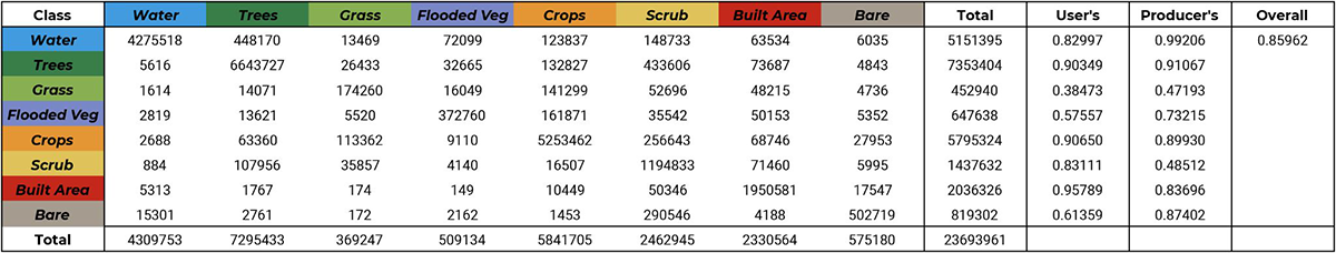
Image reproduite avec l’aimable autorisation d’ESRI.