Surveillance mondiale des mangroves
Présentation du produit
Aperçu
L’ensemble de données Global Mangrove Watch (GMW) est le résultat d’une collaboration entre l’Université d’Aberystwyth (Royaume-Uni), solo Earth Observation (soloEO ; Japon), Wetlands International, le Centre mondial de surveillance de la conservation (UNEP-WCMC) et l’Agence japonaise d’exploration aérospatiale (JAXA). L’objectif principal de la production de cet ensemble de données est de fournir aux pays qui ne disposent pas d’un système national de surveillance des mangroves des cartes préliminaires de l’étendue et de l’évolution des mangroves, afin de contribuer à la protection contre la perte et la dégradation supplémentaires des forêts de mangroves.
L’ensemble de données de Global Mangrove Watch comprend une carte de référence mondiale des mangroves pour 2010 et les changements par rapport à cette référence pour onze périodes, à savoir 1996, 2007, 2008, 2009 et 2015 à 2020. Des cartes annuelles sont prévues à partir de 2018. L’ensemble de données peut être utilisé pour identifier les écosystèmes de mangrove et surveiller les changements dans l’étendue des mangroves. Cela est important dans des applications telles que la quantification du « carbone bleu », l’atténuation des risques liés aux catastrophes naturelles et la priorisation des activités de restauration. Pour plus d’informations sur le produit Global Watch Mangrove, consultez le site Web de Global Mangrove Watch <https://www.globalmangrovewatch.org/?map=eyJiYXNlbWFwIjoibGlnaHQiLCJ2aWV3cG9ydCI6eyJsYXRpdHVkZSI6MjAsImxvbmdpdHVkZSI6MCwiem9vbSI6MiwiYmVhcmluZyI6MCwicGl0Y2giOjB9fQ%3D%3D>`__.
Digital Earth Africa offre un accès gratuit et ouvert à une copie du produit Global Mangrove Watch sur l’Afrique pour la période 1996 à 2016 provenant du Programme des Nations Unies pour l’environnement à l’adresse https://data.unep-wcmc.org/datasets/45.
Un Jupyter Notebook qui démontre le chargement et l’utilisation de cet ensemble de données dans le Sandbox est également disponible.
Spécifications
Couverture spatiale et temporelle
Les métadonnées pertinentes pour le produit Global Mangrove Watch peuvent être consultées sur l’explorateur de métadonnées DE Africa <https://explorer.digitalearth.africa/products/gmw>`__.
Tableau 1 : Spécifications du produit Global Mangrove Watch.
Spécification |
|
|---|---|
Nom du produit |
|
Taille de la cellule - X (degrés) |
0,0002 (~20 m) |
Taille de la cellule - Y (degrés) |
0,0002 (~20 m) |
Système de référence de coordonnées |
« EPSG:4326 » |
Étendue temporelle |
1996 - 2020 |
Fréquence de mise à jour |
Annuel |
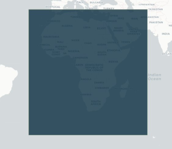
Les étendues temporelles et géographiques spécifiques du produit peuvent être explorées sous forme de carte interactive sur l’explorateur de métadonnées DE Africa <https://explorer.digitalearth.africa/products/gmw>. Les données sont disponibles pour la région ombrée en bleu.
Figure 1 : Étendue géographique du produit Global Mangrove Watch.
Mesures
Tableau 2 : Mesures des produits Global Mangrove Watch.
ID de la bande |
Description |
Unités |
Type de données |
Aucune donnée\(^\dagger\) |
|---|---|---|---|---|
mangrove |
Classification binaire où 1 correspond aux mangroves et 0 est l’absence de mangroves. |
|
|
« 0,0 » |
\(^\dagger\) Aucune donnée ni valeur de remplissage.
Traitement
Français La carte mondiale de référence des mangroves de Global Mangrove Watch pour 2010 a été générée par la classification Extremely Randomized Trees d’une combinaison de données satellitaires ALOS PALSAR en bande L (radar) et Landsat-5 et Landsat-7 (optique) couvrant les littoraux tropicaux et subtropicaux des Amériques, d’Afrique, d’Asie et d’Océanie. La classification a été contrainte à l’aide d’un masque d’habitat de mangrove, qui définissait les régions où des écosystèmes de mangrove sont susceptibles d’exister. Cette définition était basée sur des paramètres géographiques tels que la latitude, l’altitude et la distance par rapport à l’eau de mer. Les pixels de mangrove constituant les données d’entraînement à la classification ont été extraits aléatoirement d’une union de cartes mondiales de mangroves existantes de Giri et al., 2011 et Spalding et al. 2010. La génération de la carte de référence mondiale est abordée dans Bunting, P. et al., 2018.
Français Les changements dans l’étendue de la forêt de mangrove de la carte de référence de 2010 à 2014 et après ont été dérivés des données ALOS-2 PALSAR-2 (radar) tandis que les changements historiques dans l’étendue de la forêt de mangrove ont été dérivés des données JERS-1 et ALOS PALSAR (radar) en utilisant une approche de seuillage d’histogramme Thomas et al., 2017.
Médias et exemples d’images
Figure 2 : Étendue des mangroves le long de la côte du Mozambique en 1996, selon le Global Mangrove Watch.
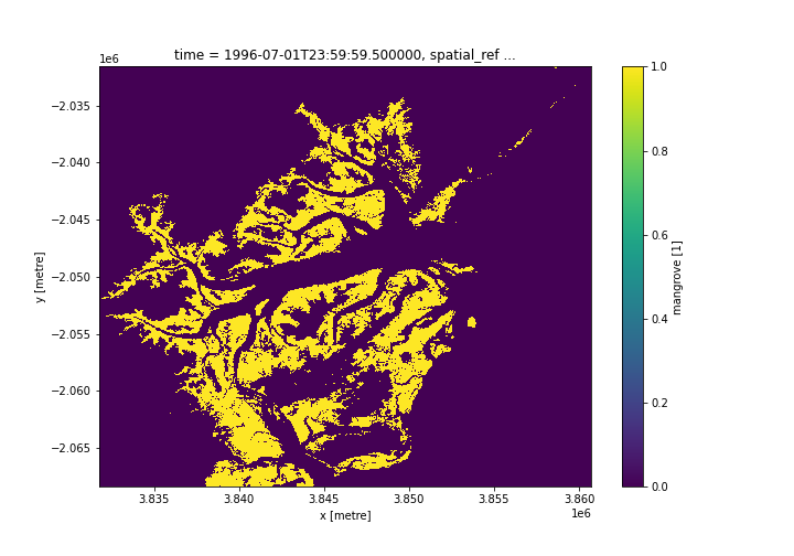
Crédit : Contient le produit Global Mangrove Watch, gracieuseté du Centre mondial de surveillance de la conservation de la nature des Nations Unies pour l’environnement, traité par Digital Earth Africa.
Références
Bunting P., Rosenqvist A., Lucas R., Rebelo L-M., Hilarides L., Thomas N., Hardy A., Itoh T., Shimada M. et Finlayson C.M. (2018). The Global Mangrove Watch – Une nouvelle base de référence mondiale de l’étendue des mangroves en 2010. Remote Sensing 10(10) : 1669. doi : 10.3390/rs1010669.
Thomas N, Lucas R, Bunting P, Hardy A, Rosenqvist A, Simard M. (2017). Distribution et facteurs de changement des forêts de mangroves à l’échelle mondiale, 1996-2010. PLOS ONE 12 : e0179302. doi : 10.1371/journal.pone.0179302
Métadonnées de Global Mangrove Watch <https://data.unep-wcmc.org/pdfs/45/GMW_001_Metadata.pdf?1560444488>`__
Plateforme en ligne Global Mangrove Watch (GMW) <https://www.globalmangrovewatch.org/>`__
Licence
L’ensemble de données Global Mangrove Watch est disponible sous une licence Creative Commons Attribution 4.0 International (CC BY 4.0). Voir https://creativecommons.org/licenses/by/4.0/ pour plus de détails.
Remerciements
L’ensemble de données Global Mangrove Watch a été généré par l’Université d’Aberystwyth et soloEO dans le cadre du projet Global Mangrove Watch (GMW), qui fait partie de l’Initiative Kyoto & Carbone de l’Agence d’exploration aérospatiale japonaise (JAXA) et du programme Mangrove Capital Africa coordonné par Wetlands International et financé par DOB Ecology.
Accès aux données
Amazon Web Services S3
Le produit Global Mangrove Watch est disponible dans AWS S3.
Tableau 3 : Détails d’accès aux données AWS.
Détails AWS S3 |
|
|---|---|
Seau ARD |
|
Région |
|
Le bucket se trouve dans la région AWS « af-south-1 » (Le Cap). Des spécifications de région supplémentaires peuvent être appliquées comme suit :
aws s3 ls --region=af-sud-1 s3://deafrica-input-datasets/
Les chemins d’accès aux fichiers suivent le format : s3://deafrica-input-datasets/gmw/<year>/.
Services Web OGC (OWS)
Le produit Global Mangrove Watch « gmw » est disponible via l’OWS de Digital Earth Africa.
Tableau 3 : Détails d’accès aux données OWS.
Détails de l’OWS |
|
|---|---|
Nom |
« DE Africa Services » |
URL des services de cartographie Web (WMS) |
|
URL du service de couverture Web (WCS) |
|
Nom de la couche |
|
Les détails de Digital Earth Africa OWS peuvent être trouvés sur https://ows.digitalearth.africa/.
Pour obtenir des instructions sur la façon de se connecter à OWS, consultez « ce tutoriel <../web_services/index.ipynb> ».
Open Data Cube (ODC)
Le produit Global Forest Watch est accessible via l’API ODC de Digital Earth Africa, qui est disponible via le « Digital Earth Africa Sandbox <https://sandbox.digitalearth.africa/hub/login> »__.
Nom du produit ODC : « gmw »
Le produit « gmw » ne possède qu’une seule bande de données spécifique qui peut être appelée en utilisant le nom par défaut, « mangrove », ou par le nom alternatif de la bande, « classification », comme indiqué dans le tableau ci-dessous. Les commandes ODC « Datacube.load » sans bandes spécifiées chargeront la bande « mangrove ».
Tableau 4 : noms de bandes GMW des produits ODC.
Nom du groupe |
Noms alternatifs |
Remplir la valeur |
|---|---|---|
mangrove |
classification |
0,0 |
Informations techniques
La qualité de Global Mangrove Watch a été évaluée en 2018 en évaluant la précision de la classification sur 53 800 points échantillonnés de manière aléatoire dans 20 régions sélectionnées de manière aléatoire. La précision globale globale s’est avérée être de 95,25 %, les précisions de l’utilisateur et du producteur pour la classe de mangrove étant estimées respectivement à 97,5 % et 94,0 %. La méthode de validation est décrite dans Bunting, P. et al., 2018 <https://www.mdpi.com/2072-4292/10/10/1669>.