ESA - WorldCereal
Date modified: September 2025
Overview
Aperçu
The ESA WorldCereal project delivers a globally consistent, satellite-derived system for monitoring cropland extent, crop types, and irrigation practices. Designed for seasonal agricultural monitoring at 10 m resolution, the system uses optical and radar data from Sentinel-1 SAR and Sentinel-2 MSI, enabling frequent, cloud-resilient observations across diverse agro-ecological zones. The initiative builds on earlier prototyping efforts and now provides a fully open-source, harmonized processing system accessible via the Copernicus Data Space Ecosystem European Space Agency ESA, 2025.
Key outputs include annual temporary cropland extent, seasonal crop type classifications (e.g., cereals and maize), irrigation status, and associated confidence layers. These products are available globally but are particularly relevant for regions with food security challenges, such as sub-Saharan Africa and South Asia. Products are mapped using agro-ecological zones to account for regional planting calendars, and the system supports the co-creation of customized models using user-supplied in-situ reference data.
All maps are provided in standardized spatial grids (EPSG:4326), with versioned outputs and quality metrics validated against ground observations. The platform also includes a global reference data module, enabling the sharing, curation, and retrieval of harmonized crop ground-truth data. Ongoing improvements in model training, algorithm optimization, and atmospheric correction enhance product accuracy and usability over time.
Comprehensive documentation—including technical manuals, user guides, Jupyter Notebooks, and training resources—is freely available to support researchers, decision-makers, and agricultural monitoring agencies worldwide European Space Agency ESA, 2025.
Digital Earth Africa (DE Africa) hosts these datasets for the African region, providing free and open access to both the data and associated tools through the DE Africa Sandbox. Below are the WorldCereal available via DE Africa.
Temporary Cropland Extent 2021
This dataset provides a high-resolution map of temporary cropland extent, derived from Sentinel‑1 SAR and Sentinel‑2 MSI observations. It identifies areas under active cultivation (excluding permanent crops and pastures) at 10 m resolution for 2021. The product includes binary classification layers, offering a consistent and harmonized baseline for agricultural monitoring and land use planning. Mapping is performed per agro-ecological zone (AEZ) to account for local phenology. The dataset supports food security assessments, agricultural statistics, and environmental research. For more details, general information is available here, and the Product Manual provides comprehensive technical guidance.
Active Cropland
This dataset represents areas under active cultivation during the main agricultural seasons in 2021. Derived from Sentinel‑1 and Sentinel‑2 time series, it provides a binary classification of cropland—highlighting parcels with vegetation growth dynamics. Designed for seasonal monitoring, the dataset helps distinguish actively farmed areas from fallow or uncultivated land. Confidence layers and agro-ecological zone–specific modeling support accurate local interpretation.
Maize Cropland
This product provides seasonal classification maps of maize for 2021. Derived from Sentinel-1 and Sentinel-2 time series, the dataset captures cropping patterns at 10 m resolution across agro-ecological zones. Each map is accompanied by a confidence layer. Designed to support regional and national crop monitoring systems, the data are especially useful for early warning, market forecasting, drought risk assessment, irrigation planning, and food security analyses. For more details, general information is available here, and the Product Manual provides comprehensive technical guidance.
Below is a description of the maize-related products indexed in DE Africa, clarifying their distinctions—particularly important given how many include maize in their names:
- Active Main MaizeRepresents an active cropland map for the main maize season defined in each region. It captures general active cropland during that season—not restricted to maize alone.
- Main MaizeRefers specifically to a maize crop map for the main maize season defined in a region. This product captures maize-only cultivation.
- Irrigated MaizeDesigned to identify all active crops cultivated under both rainfed and irrigated conditions during the main maize season. This helps distinguish water management practices associated with maize production.
Winter Cereal Cropland
This product provides seasonal classification maps of key crop types—specifically winter cereals (e.g., wheat, barley, rye) for the year 2021. Generated from Sentinel-1 and Sentinel-2 time series, the dataset captures regional cropping patterns at 10 m resolution across agro-ecological zones. Each map is accompanied by a corresponding confidence layer. Designed to support both regional and national crop monitoring systems, the data are especially useful for early warning, market forecasting, drought risk assessment, irrigation management, and food security assessments. For more details, general information is available here, and the Product Manual provides comprehensive technical guidance.
Below are the winter cereal-related products indexed in DE Africa, with their definitions:
- Winter CerealRefers specifically to a winter cereal crop map for the defined winter season in a region. This product captures cropland planted with cereals such as wheat, barley, or rye.
- Irrigated Winter CerealDesigned to identify winter cereal cropland cultivated under both rainfed and irrigated conditions during the winter season. This layer helps distinguish water management practices associated with winter cereal production.
Spécifications
Relevant coverage and metadata for each of the datasets can be viewed on DE Africa Metadata Explorer:
WorldCereal Temporary Cropland Extent 2021 (raster 10 m), annual – version 1
WorldCereal Active Cropland 2021 (raster 10 m), seasonal – version 1
WorldCereal Maize – Main Season 2021 (raster 10 m), seasonal – version 1
WorldCereal Maize – Active Season 2021 (raster 10 m), seasonal – version 1
WorldCereal Maize – Irrigation 2021 (raster 10 m), seasonal – version 1
WorldCereal Winter Cereals 2021 (raster 10 m), seasonal – version 1
WorldCereal Winter Cereals – Irrigation 2021 (raster 10 m), seasonal – version 1
WorldCereal Products
Caractéristiques
Table 1: Temporary Cropland Products
Spécification |
WorldCereal Temporary Cropland 2021 (10 m) v1 |
|---|---|
Cell size (metres) |
10 x 10 |
Coordinate Reference System |
EPSG:4326 (WGS 84) |
Résolution temporelle |
Annuel |
Plage temporelle |
2021 |
Version |
1 |
Ensemble de données parent |
Sentinel-1 SAR, Sentinel-2 MSI |
Fréquence de mise à jour |
Annual composite |
Access |
Free and open via DE Africa |
Table 2: Maize-Specific Products (2021)
Spécification |
Maize – Active ( |
Maize – Main Season ( |
|---|---|---|
Cell size (metres) |
10 x 10 |
10 x 10 |
Coordinate Reference System |
EPSG:4326 (WGS 84) |
EPSG:4326 (WGS 84) |
Résolution temporelle |
Seasonal |
Seasonal |
Plage temporelle |
2021 |
2021 |
Version |
1 |
1 |
Ensemble de données parent |
Sentinel-1 SAR, Sentinel-2 MSI |
Sentinel-1 SAR, Sentinel-2 MSI |
Fréquence de mise à jour |
Seasonal (per cropping calendar) |
Seasonal (per cropping calendar) |
Access |
Free and open via DE Africa |
Free and open via DE Africa |
Spécification |
Maize – Irrigation ( |
|---|---|
Cell size (metres) |
10 x 10 |
Coordinate Reference System |
EPSG:4326 (WGS 84) |
Résolution temporelle |
Seasonal |
Plage temporelle |
2021 |
Version |
1 |
Ensemble de données parent |
Sentinel-1 SAR, Sentinel-2 MSI |
Fréquence de mise à jour |
Seasonal (per cropping calendar) |
Access |
Free and open via DE Africa |
Table 3: Winter Cereals Products (2021)
Spécification |
Winter Cereals ( |
Winter Cereals – Irrigation ( |
|---|---|---|
Cell size (metres) |
10 x 10 |
10 x 10 |
Coordinate Reference System |
EPSG:4326 (WGS 84) |
EPSG:4326 (WGS 84) |
Résolution temporelle |
Seasonal |
Seasonal |
Plage temporelle |
2021 |
2021 |
Version |
1 |
1 |
Ensemble de données parent |
Sentinel-1 SAR, Sentinel-2 MSI |
Sentinel-1 SAR, Sentinel-2 MSI |
Fréquence de mise à jour |
Seasonal (winter cropping zones) |
Seasonal (winter cropping zones) |
Access |
Free and open via DE Africa |
Free and open via DE Africa |
Measurements
Table 4: Measurement
Measurement |
Temporary Cropland ( |
Active Cropland ( |
|---|---|---|
Binary Classification |
Yes |
Yes |
Crop Type (Maize/Winter Cereal) |
No |
No |
Irrigation Status |
No |
No |
Confidence Layer |
Yes |
Yes |
Measurement |
Maize Main ( |
Maize Irrigation ( |
|---|---|---|
Binary Classification |
Yes |
Yes |
Crop Type (Maize/Winter Cereal) |
Yes |
Yes |
Irrigation Status |
No |
Yes |
Confidence Layer |
Yes |
Yes |
Measurement |
Winter Cereals ( |
Winter Cereals Irrigation ( |
|---|---|---|
Binary Classification |
Yes |
Yes |
Crop Type (Maize/Winter Cereal) |
Yes |
Yes |
Irrigation Status |
No |
Yes |
Confidence Layer |
Yes |
Yes |
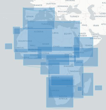
Geographic Extent
All products in the WorldCereal collection share the same geographic extent, as illustrated in Figure 1; data are available for the regions shaded in blue. Specific temporal and geographic extents for each product can be explored interactively using the Digital Earth Africa Metadata Explorer. Different WorldCereal products can be selected from the horizontal dropdown menu at the top of the page.
Figure 1: WorldCereal geographic extent
Traitement
The complete processing methodology for these products is detailed in the Technical Manual.
Médias et exemples d’images
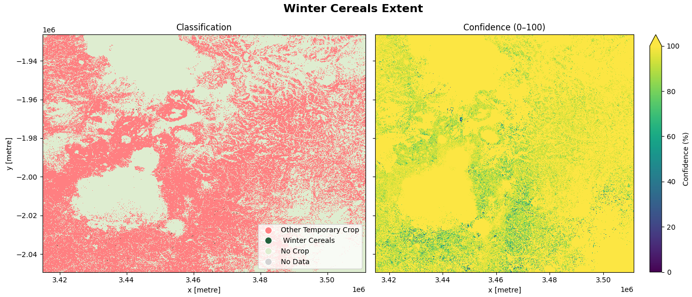
The images below present the WorldCereals data for a farmland area in Mozambique.
Image 1: WorldCereal Temporary Cropland
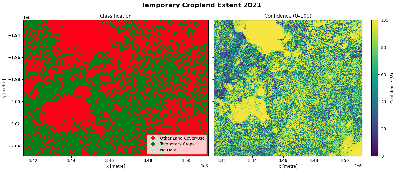
Image 2: WorldCereal Active Cropland
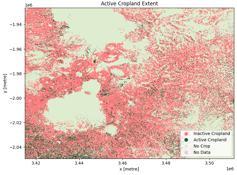
Image 3: WorldCereal Main-Season Maize Cropland
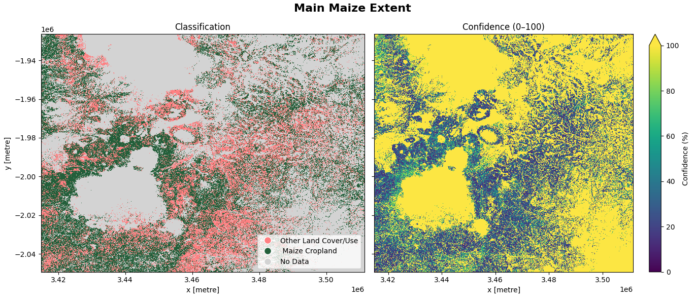
Image 4: WorldCereal Winter Cereal Cropland
Licence
Licence internationale CC BY Attribution 4.0
Remerciements
The ESA WorldCereal products were produced by the European Space Agency (ESA) in collaboration with VITO and project partners, and are freely provided via the Copernicus Global Land Service. Data access and regional support is enable by Digital Earth Africa.
Références
European Space Agency. (2025). Introducing WorldCereal. ESA. https://www.esa.int/Applications/Observing_the_Earth/Introducing_World_Cereal
Accès aux données
Amazon Web Services S3
The Digital Earth Africa WorldCereal products can be accessed from the associated S3 bucket.
Tableau 5 : Détails de l’accès aux données AWS
Détails AWS S3 |
|
|---|---|
ARN du compartiment |
|
Noms de produits |
|
Le seau est situé dans la région « af-south-1 » (Le Cap)
Tableau 9 : Convention de chemin d’accès au fichier AWS
Élément de chemin de fichier |
Description |
Exemple |
|---|---|---|
« nom du produit » |
|
|
|
Version du produit |
« 1-0-0 » |
Services Web OGC (OWS)
Ce produit est disponible via OWS de DE Africa.
Tableau 10 : Détails d’accès aux données OWS.
Détails de l’OWS |
|
|---|---|
Nom |
« DE Africa Services » |
URL des services de cartographie Web (WMS) |
|
URL du service de couverture Web (WCS) |
|
Noms des calques |
|
Les détails de Digital Earth Africa OWS peuvent être trouvés sur https://ows.digitalearth.africa/.
Pour obtenir des instructions sur la façon de se connecter à OWS, consultez « ce tutoriel <../web_services/index.ipynb> ».
Open Data Cube (ODC)
The WorldCereal collection can be accessed through the Digital Earth Africa ODC API, which is available through the Digital Earth Africa Sandbox.
ODC product name: esa_worldcereal_temporarycrops, esa_worldcereal_activecropland, esa_worldcereal_maize_main, esa_worldcereal_maize_active, esa_worldcereal_maize_irrigation, esa_worldcereal_wintercereals, esa_worldcereal_wintercereals_irrigation