Couverture mondiale de l’ESA
Date de modification : 31 juillet 2022
Présentation du produit
Aperçu
Le produit ESA WorldCover est une carte mondiale de la couverture terrestre en libre accès à une résolution de 10 m pour les années 2020 et 2021, basée sur les données Sentinel-1 et Sentinel-2. La carte de classification discrète fournit 11 classes de couverture/utilisation des terres et est définie à l’aide du système de classification de la couverture terrestre (LCCS) développé par l’Organisation des Nations Unies pour l’alimentation et l’agriculture (FAO).
Digital Earth Africa offre un accès gratuit et ouvert à une copie du produit ESA WorldCover 10m pour 2020 et 2021 sur l’Afrique. Pour plus d’informations sur le produit ESA WorldCover, consultez le site Web ESA WorldCover <https://esa-worldcover.org/>.
Manuel d’utilisation du produit
Manuel d’utilisation du produit pour ESA WorldCover 2020
Manuel d’utilisation du produit pour ESA WorldCover 2021
Un Jupyter Notebook qui démontre le chargement et l’utilisation des ensembles de données de couverture terrestre dans le Sandbox est également disponible.
Spécifications
Couverture spatiale et temporelle
Les métadonnées pertinentes pour le produit ESA WorldCover peuvent être consultées sur l’explorateur de métadonnées DE Africa <https://explorer.digitalearth.africa/products/esa_worldcover>`__.
Tableau 1 : Spécifications du produit ESA WorldCover
Spécification |
|
|---|---|
Nom du produit |
|
Taille de la cellule - X (degrés) |
0,000083° (~10m) |
Taille de la cellule - Y (degrés) |
0,000083° (~10m) |
Système de référence de coordonnées |
« EPSG:4326 » |
Résolution temporelle |
Annuel |
Plage temporelle |
2020 , 2021 |
Fréquence de mise à jour |
Annuel |
Les étendues temporelles et géographiques spécifiques du produit peuvent être explorées sous forme de carte interactive dans l’explorateur de métadonnées <https://explorer.digitalearth.africa/products/esa_worldcover>. Les données sont disponibles pour la région ombrée en bleu.
Figure 1 : Étendue géographique du produit ESA WorldCover

Mesures
Tableau 2 : Mesures du produit ESA WorldCover
ID de la bande |
Description |
Unités |
Type de données |
Aucune donnée\(^\dagger\) |
|---|---|---|---|---|
classification |
Classification de l’occupation du sol |
1 |
uint8 |
0,0 |
Traitement
Le produit de couverture terrestre mondiale ESA WorldCover a été généré à l’aide d’images multispectrales Sentinel-2 et d’images radar à synthèse d’ouverture (SAR) en bande C Sentinel-1. L’algorithme utilisé pour générer le produit est basé sur l’algorithme utilisé pour produire la carte annuelle dynamique de couverture terrestre du Copernicus Global Land Service à une résolution de 100 m (CGLS_LC100m). Un résumé de l’algorithme est présenté dans le « Manuel d’utilisation du produit <https://esa-worldcover.s3.amazonaws.com/v100/2020/docs/WorldCover_PUM_V1.0.pdf> » pour 2020 et le « Manuel d’utilisation du produit <https://worldcover2021.esa.int/data/docs/WorldCover_PVR_V2.0.pdf> » pour 2021.
Médias et exemples d’images
Figure 2 : Données de classification de la couverture terrestre ESA WorldCover 2020 pour Madagascar
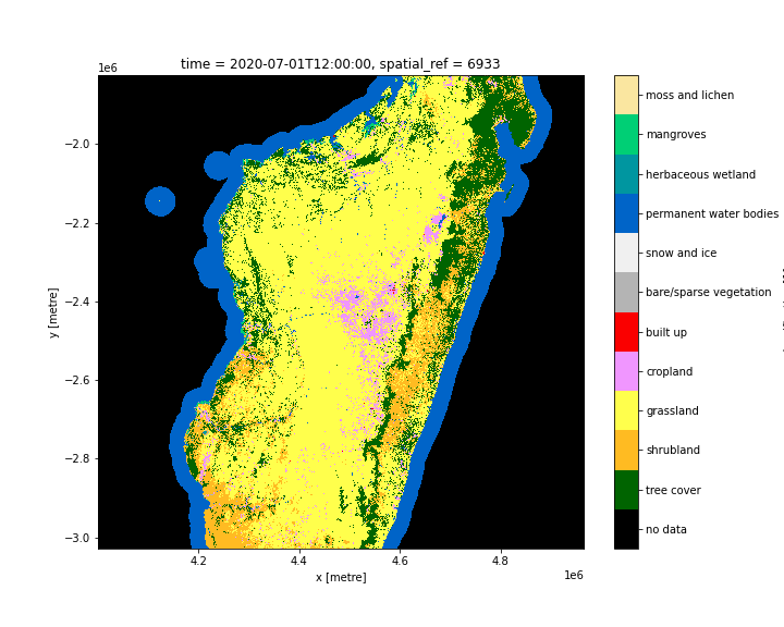
Figure 3 : Données de classification de la couverture terrestre ESA WorldCover 2021 pour Madagascar
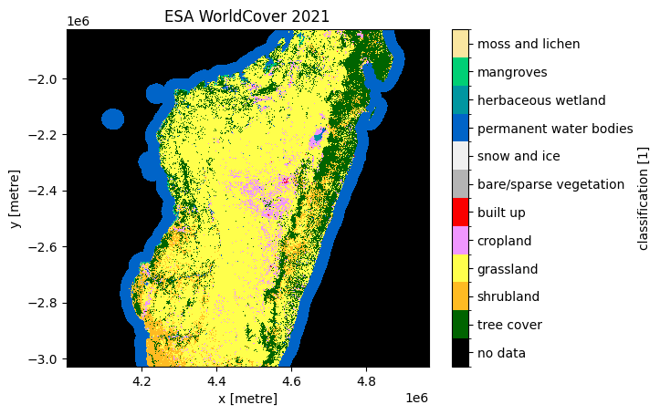
© Projet ESA WorldCover 2021 / Contient des données Copernicus Sentinel modifiées (2021) traitées par le consortium ESA WorldCover
Références
Zanaga, D., Van De Kerchove, R., De Keersmaecker, W., Souverijns, N., Brockmann, C., Quast, R., Wevers, J., Grosu, A., Paccini, A., Vergnaud, S., Cartus, O., Santoro, M., Fritz, S., Georgieva, I., Lesiv, M., Carter, S., Herold, M., Li, Linlin, Tsendbazar, N.E., Ramoino, F. , Arino, O., 2021. ESA WorldCover 10 m 2020 v100. https://doi.org/10.5281/zenodo.5571936
Zanaga, D., Van De Kerchove, R., Daems, D., De Keersmaecker, W., Brockmann, C., Kirches, G., Wevers, J., Cartus, O., Santoro, M., Fritz, S., Lesiv, M., Herold, M., Tsendbazar, N.E., Xu, P., Ramoino, F., Arino, O. ESA WorldCover 10 m 2021 v200 https://zenodo.org/record/7254221
Licence et Remerciements
Le produit ESA WorldCover est fourni gratuitement, sans restriction d’utilisation. Pour obtenir les informations complètes sur la licence, consultez la licence internationale Creative Commons Attribution 4.0 <https://creativecommons.org/licenses/by/4.0/>.
Accès aux données
Amazon Web Service
Les produits ESA WorldCover 10m 2020 et 2021 sont disponibles dans AWS S3.
Tableau 3 : Détails d’accès aux données AWS.
Détails AWS S3 |
|
|---|---|
Seau ARD |
|
Région |
« eu-central-1 » |
Les produits sont hébergés sur le bucket S3 « esa-worldcover » dans la région AWS « eu-central-1 ».
Les chemins d’accès aux fichiers suivent le format : https://esa-worldcover.s3.eu-central-1.amazonaws.com/v100/{year}/map/
Services Web OGC (OWS)
Le produit ESA WorldCover 10m « esa_worldcover » est disponible via l’OWS de Digital Earth Africa.
Tableau 4 : Détails d’accès aux données OWS.
Détails de l’OWS |
|
|---|---|
Nom |
« DE Africa Services » |
URL des services de cartographie Web (WMS) |
|
URL du service de couverture Web (WCS) |
|
Nom de la couche |
|
Les détails de Digital Earth Africa OWS peuvent être trouvés sur https://ows.digitalearth.africa/.
Pour obtenir des instructions sur la façon de se connecter à OWS, consultez « ce tutoriel <../web_services/index.ipynb> ».
Open Data Cube (ODC)
Le produit ESA WorldCover est accessible via l’API ODC de Digital Earth Africa, qui est disponible via le « Digital Earth Africa Sandbox <https://sandbox.digitalearth.africa/hub/login> »__.
Nom du produit ODC : esa_worldcover_{year}
Le produit « esa_worldcover » ne possède qu’une seule bande de données spécifique qui peut être appelée en utilisant le nom par défaut, « classification », comme indiqué dans le tableau ci-dessous. Les commandes ODC « Datacube.load » sans bandes spécifiées chargeront la bande « classification ».
Tableau 5 : Noms des bandes du produit ODC esa_worldcover.
Nom du groupe |
Noms alternatifs |
Remplir la valeur |
|---|---|---|
classification |
NaN |
« 0,0 » |
Informations techniques
Le produit ESA WorldCover a été validé de manière indépendante avec les précisions indiquées ci-dessous :
Nom du produit |
Mondial |
Afrique |
|---|---|---|
ESA WorldCover 2020 |
« 74,4 % ± 0,1 % » |
« 73,6 % ± 0,2 % » |
Couverture mondiale de l’ESA 2021 |
« 76,7 % ± 0,5 » |
« 76,5 % ± 1,3 » |
En termes de types de couverture terrestre, les classes de couverture arborée et de neige/glace, de terres cultivées, de plans d’eau et de végétation nue/éparsemée présentaient des précisions élevées, tandis que les classes d’arbustes, de zones humides herbacées et de mousses/lichens étaient cartographiées avec une précision moindre. L’ensemble de données de validation utilisé était l’ensemble de données polyvalent Global Land Cover Validation développé pour le produit Copernicus Global Land Service- Land Cover 100 qui a été mis à jour pour l’année de référence 2020 en revisitant des sous-ensembles aléatoires et ciblés (pour les changements de couverture terrestre).
Dans l’ensemble, le produit WorldCover 2021 v200 montre des améliorations prometteuses dans la caractérisation de la couverture terrestre mondiale à une résolution de 10 m en utilisant les données Sentinel 1 et Sentinel 2 pour l’année 2021. Les utilisateurs de la carte sont encouragés à utiliser l’analyse de précision statistique au niveau mondial et continental pour appliquer au mieux le produit WorldCover à leurs besoins.
Une explication détaillée des résultats de validation du produit ESA WorldCover 10m est présentée dans :