Estimations des précipitations (CHIRPS)
Date de modification : 12 janvier 2022
Présentation du produit
Aperçu
Digital Earth Africa (DE Africa) propose un accès gratuit et ouvert à une copie des produits mensuels et quotidiens du Climate Hazards Group InfraRed Precipitation with Station data (CHIRPS) sur l’Afrique. Les cartes de précipitations CHIRPS sont produites et fournies par le Climate Hazards Center en collaboration avec l’US Geological Survey et utilisent à la fois des observations pluviométriques et satellitaires.
L’ensemble de données « CHIRPS-2.0 Africa Monthly » est régulièrement indexé sur DE Africa à partir des « données mensuelles CHIRPS <https://data.chc.ucsb.edu/products/CHIRPS-2.0/africa_monthly/tifs/> ». L’ensemble de données « CHIRPS-2.0 Africa Daily » est également indexé à partir des « données quotidiennes CHIRPS <https://data.chc.ucsb.edu/products/CHIRPS-2.0/africa_daily/tifs/> ». Les deux produits ont été convertis en GeoTIFF optimisés pour le cloud et sont accessibles via l’Open Data Cube de DE Africa. Cela signifie que l’archive complète des précipitations quotidiennes et mensuelles CHIRPS peut être facilement utilisée pour l’inspection ou l’analyse sur les plateformes DE Africa, y compris la carte interactive DE Africa <https://maps.digitalearth.africa/> ».
Un Jupyter Notebook qui démontre le chargement et l’utilisation des ensembles de données CHIRPS dans le Sandbox est également disponible.
Cette page détaille comment accéder aux produits CHIRPS via les plateformes DE Africa. Pour plus d’informations sur l’ensemble de données, consultez le site Web officiel CHIRPS <https://www.chc.ucsb.edu/data/chirps> :
« L’estimation des variations des précipitations dans l’espace et dans le temps est un aspect essentiel de l’alerte précoce en cas de sécheresse et de la surveillance environnementale. Une saison plus sèche que la normale doit être replacée dans un contexte historique afin de pouvoir évaluer rapidement la gravité des déficits pluviométriques. Cependant, les estimations dérivées des données satellitaires fournissent des moyennes surfaciques qui souffrent de biais dus à la complexité du terrain, qui sous-estime souvent l’intensité des événements de précipitations extrêmes. À l’inverse, les grilles de précipitations produites à partir des données des stations souffrent dans les régions plus rurales où il y a moins de stations pluviométriques. CHIRPS a été créé en collaboration avec des scientifiques du Centre EROS (Earth Resources Observation and Science) de l’USGS afin de fournir des ensembles de données complets, fiables et à jour pour un certain nombre d’objectifs d’alerte précoce, comme l’analyse des tendances et la surveillance saisonnière des sécheresses. »
Spécifications
Couverture spatiale et temporelle
DE Africa fournit les ensembles de données mensuels et quotidiens CHIRPS sous forme de deux produits distincts.
Tableau 1 : Spécifications des produits CHIRPS de mesure des précipitations
Spécification |
||
|---|---|---|
Nom du produit |
Précipitations - CHIRPS quotidien |
Précipitations - CHIRPS mensuel |
Taille de la cellule - X (degrés) |
0,05 (~5 km) |
0,05 (~5 km) |
Taille de la cellule - Y (degrés) |
0,05 (~5 km) |
0,05 (~5 km) |
Système de référence de coordonnées |
EPSG: 4326 |
EPSG: 4326 |
Résolution temporelle |
1 jour |
1 mois |
Plage temporelle |
1981 – aujourd’hui |
1981 – aujourd’hui |
Fréquence de mise à jour |
Tous les jours |
Mensuel |
Tableau 2 : Mesures des produits CHIRPS de précipitations
Nom du produit |
ID de la bande |
Description |
Unités |
Type de données |
Aucune valeur de données |
|---|---|---|---|---|---|
Précipitations - CHIRPS quotidien |
précipitations |
Précipitations atmosphériques mensuelles |
« mm » |
|
|
Précipitations - CHIRPS mensuel |
précipitations |
Précipitations atmosphériques quotidiennes |
« mm » |
|
|
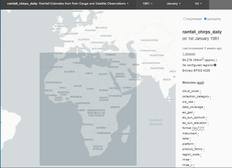
Les deux produits CHIRPS relatifs aux précipitations ont la même étendue géographique. Les données sont disponibles pour la région ombrée dans la figure 1.
Des étendues temporelles et géographiques spécifiques peuvent être explorées sous forme de carte interactive sur l’explorateur de métadonnées Digital Earth Africa :
Figure 1 : Étendue géographique des produits CHIRPS
Traitement
L’algorithme Climate Hazards group Infrared Precipitation with Stations (CHIRPS) a été développé par le Climate Hazards Center <https://www.chc.ucsb.edu/data/chirps>`__ et est décrit dans Funk, C., Peterson, P., Landsfeld, M. et al. (2015).
Médias et exemples d’images
Image 1 : Animation des précipitations mensuelles CHIRPS au Nigéria de 2020 à 2021.

Crédit : Contient Rainfall CHIRPS Produit avec l’aimable autorisation du Climate Hazards Center, traité par Digital Earth Africa.
Image 2 : Précipitations mensuelles moyennes pour 2020, calculées à l’aide des précipitations mensuelles CHIRPS.
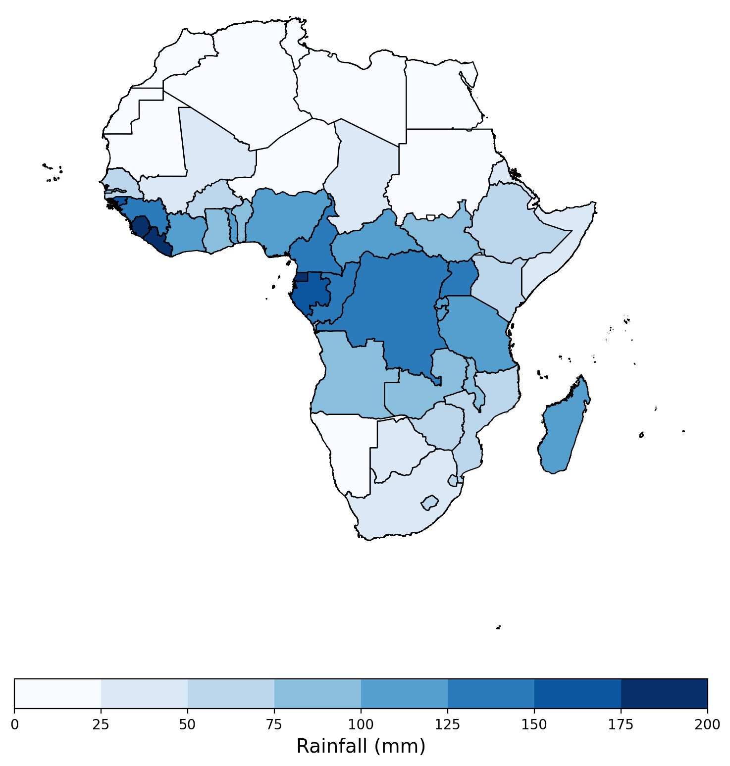
Crédit : Contient Rainfall CHIRPS Produit avec l’aimable autorisation du Climate Hazards Center, traité par Digital Earth Africa.
Références
Funk, C., Peterson, P., Landsfeld, M. et al. (2015). Les précipitations infrarouges liées aux risques climatiques avec des stations : un nouveau record environnemental pour la surveillance des extrêmes. Sci Data 2, 150066. https://doi.org/10.1038/sdata.2015.66
Site Web CHIRPS <https://www.chc.ucsb.edu/data/chirps>`__
Licence
Les données CHIRPS sont dans le domaine public et sont enregistrées auprès de Creative Commons. Extrait du site Web CHIRPS :
Dans la mesure où la loi le permet, Pete Peterson a renoncé à tous les droits d’auteur et droits connexes ou voisins sur Climate Hazards Group Infrared Precipitation with Stations (CHIRPS).
Remerciements
Les produits mensuels et quotidiens CHIRPS sont fournis par le Climate Hazards Center (CHC), UC Santa Barbara.
Accès aux données
Amazon Web Service S3
Les produits Digital Earth Africa CHIRPS sont disponibles dans AWS S3.
Tableau 3 : Détails de l’accès aux données AWS
Détails AWS S3 |
|
|---|---|
ARN du compartiment |
|
Région |
|
Nom du produit |
|
Le bucket se trouve dans la région AWS « af-south-1 » (Le Cap). Des spécifications de région supplémentaires peuvent être appliquées comme suit :
aws s3 ls --region=af-sud-1 s3://deafrica-input-datasets/
Les conventions de chemin de fichier suivantes s’appliquent respectivement aux produits « rainfall_chirps_monthly » et « rainfall_chirps_daily » :
s3://deafrica-input-datasets/rainfall_chirps_monthly/
s3://deafrica-input-datasets/rainfall_chirps_daily/<année>/<mois>/
Services Web OGC (OWS)
Le produit CHIRPS « rainfall_chirps_monthly » est disponible via OWS de Digital Earth Africa.
Tableau 4 : Détails d’accès aux données OWS
Détails de l’OWS |
|
|---|---|
Nom |
« DE Africa Services » |
URL des services de cartographie Web (WMS) |
|
URL du service de couverture Web (WCS) |
|
Nom de la couche |
|
Les détails de Digital Earth Africa OWS peuvent être trouvés sur https://ows.digitalearth.africa/.
Pour obtenir des instructions sur la façon de se connecter à OWS, consultez « ce tutoriel <../web_services/index.ipynb> ».
Open Data Cube (ODC)
Les produits CHIRPS sont accessibles via l’API ODC de Digital Earth Africa, qui est disponible via le « Digital Earth Africa Sandbox <https://sandbox.digitalearth.africa/hub/login> »__.
Noms de produits ODC : rainfall_chirps_monthly, rainfall_chirps_daily
Les produits « rainfall_chirps_monthly » et « rainfall_chirps_daily » n’ont qu’une seule bande de données, « rainfall », qui peut être appelée en utilisant le nom de la bande comme indiqué dans le tableau ci-dessous. Les commandes ODC « Datacube.load » sans mesures spécifiées chargeront également la bande « rainfall ».
Tableau 5 : Précipitations - Produits ODC CHIRPS et noms de bandes
Nom du produit |
Nom du groupe |
Noms alternatifs |
|---|---|---|
|
précipitations |
– |
|
précipitations |
– |
Les noms de produits et de groupes sont sensibles à la casse.
Des instructions sur la manière d’accéder et d’utiliser les produits CHIRPS du DE Africa Open Data Cube sont fournies dans l’exemple de bloc-notes de jeu de données Rainfall CHIRPS <.notebooks/Datasets/Rainfall_CHIRPS.html>`__.
Informations techniques
Les données de précipitations infrarouges du Climate Hazards Group avec station (CHIRPS) sont un ensemble de données quasi-globales sur les précipitations couvrant plus de 35 ans, couvrant 50°S-50°N (et toutes les longitudes) et allant de 1981 à nos jours. CHIRPS intègre la climatologie des précipitations du Climate Hazards Group (CHPclim) qui intègre des informations satellitaires pour représenter des emplacements peu mesurés, des estimations des précipitations infrarouges du Climate Hazards Group basées sur CCD uniquement par satellite à résolution de 0,05° (CHIRP) et des données de station in situ pour créer des séries chronologiques de précipitations quadrillées pour l’analyse des tendances et la surveillance saisonnière des sécheresses.
Pour plus d’informations sur l’algorithme utilisé pour générer les ensembles de données CHIRPS, visitez la publication CHIRPS <https://doi.org/10.1038/sdata.2015.66>`__.