Couverture terrestre mondiale du service mondial Copernicus à une résolution spatiale de 100 m
Date de modification : 25 janvier 2021
Présentation du produit
Aperçu
Digital Earth Africa (DE Africa) offre un accès gratuit et ouvert à une copie de la collection 3 (version 3) du produit Copernicus Global Land Service Annual Dynamic Global Land Cover à une résolution spatiale de 100 m (CGLS_LC100m) sur l’Afrique pour les années 2015 à 2019.
Le produit CGLS_LC100m est une collection annuelle de couches de couverture terrestre produite par le Copernicus Global Land Monitoring Service (CGLS). Chaque période de cartographie contient 14 à 15 couches :
Une couche de classification de la couverture terrestre discrète (fournit 23 classes définies selon le schéma LCCS de la FAO)
Couches de couverture fractionnaires pour 10 classes de couverture terrestre (végétation nue/clairsemée, terres cultivées, prairies herbacées, mousses et lichens, arbustes, arbres, neige et glace permanentes, agglomérations, eau permanente, eau saisonnière)
Une couche de type de forêt (type de forêt pour tous les pixels où la fraction de couverture arborée est supérieure à 1 %)
Une couche de probabilité de classification discrète (indicateur de qualité du classificateur)
Indicateur de densité de données pour les données d’entrée PROBA-V UTM 100m (qualité des données d’entrée EO entre 0 et 100 (0 = mauvaise, 100 = données parfaites))
Couche de confiance de changement montrant la certitude qu’un changement s’est produit par rapport à l’année précédente (livrée uniquement pour les couches produites en mode conso ou nrt)
DE Africa fournit 13 de ces couches qui sont décrites dans la section « Mesures <#Mesures> ».
Cette page détaille comment accéder au produit CGLS_LC100m via les plateformes DE Africa. Pour plus d’informations sur l’ensemble de données, consultez le manuel d’utilisation du produit <https://doi.org/10.5281/zenodo.4723921> et la publication <https://doi.org/10.3390/rs12061044>.
Un Jupyter Notebook qui démontre le chargement et l’utilisation des ensembles de données de couverture terrestre dans le Sandbox est également disponible.
Spécifications
Couverture spatiale et temporelle.
Les métadonnées pertinentes pour le produit Copernicus Global Land Service Land Use/Land Cover à 100 m peuvent être consultées sur l’explorateur de métadonnées DE Africa <https://explorer.digitalearth.africa/products/cgls_landcover>`__.
Tableau 1 : Spécifications du produit Copernicus Global Land Service relatif à l’utilisation et à la couverture du sol à 100 m.
Spécification |
|
|---|---|
Nom du produit |
|
Taille de la cellule - X (degrés) |
-0,001° (~100m) |
Taille de la cellule - Y (degrés) |
-0,001° (~100m) |
Système de référence de coordonnées |
EPSG:4326 |
Résolution temporelle |
Annuel |
Plage temporelle |
2015 – 2019 |
Fréquence de mise à jour |
Annuel |
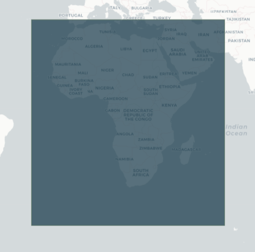
Les étendues temporelles et géographiques spécifiques du produit peuvent être explorées sous forme de carte interactive sur l’explorateur de métadonnées DE Africa <https://explorer.digitalearth.africa/products/cgls_landcover>. Les données sont disponibles pour la région ombrée en bleu.
Figure 1 : Utilisation des terres/couverture des terres du Copernicus Global Land Service à une étendue géographique de 100 m.
Mesures
Tableau 2 : Mesures du produit Utilisation/Couverture du sol du Copernicus Global Land Service à 100 m.
ID de la bande |
Description |
Unités |
Gamme |
Type de données |
Aucune donnée\(^\dagger\) |
|---|---|---|---|---|---|
classification |
Classification de l’occupation du sol |
1 |
0 - 200 |
uint8 |
255 |
type_de_forêt |
Type de forêt pour tous les pixels avec un pourcentage d’arbres couvert de végétation supérieur à 1 % |
pour cent |
0 - 5 |
uint8 |
255 |
classification_probabilité |
Indicateur de qualité (probabilité de classification) de la classification discrète |
pour cent |
0 - 100 |
uint8 |
255 |
fraction_de_couverture_nue |
Pourcentage de couverture végétale pour la classe de couverture terrestre à végétation clairsemée et nue |
pour cent |
0 - 100 |
uint8 |
255 |
fraction_de_couverture_construite |
Pourcentage de couverture du sol pour la classe de couverture du sol bâti |
pour cent |
0 - 100 |
uint8 |
255 |
fraction_de_couverture_des_cultures |
Pourcentage de couverture végétale pour la classe de couverture du sol des terres cultivées |
pour cent |
0 - 100 |
uint8 |
255 |
fraction_de_couverture_herbeuse |
Pourcentage de couverture végétale pour la classe de couverture terrestre de végétation herbacée |
pour cent |
0 - 100 |
uint8 |
255 |
fraction_de_couverture_moussée |
Pourcentage de couverture végétale pour la classe de couverture terrestre des mousses et des lichens |
pour cent |
0 - 100 |
uint8 |
255 |
fraction_de_couverture_en_eau_permanente |
Pourcentage de couverture du sol pour la classe de couverture terrestre permanente des eaux |
pour cent |
0 - 100 |
uint8 |
255 |
fraction_de_couverture_en_eau_saisonnière |
Pourcentage de couverture du sol pour la classe de couverture terrestre saisonnière des eaux |
pour cent |
0 - 100 |
uint8 |
255 |
fraction_de_couverture_arbustive |
Pourcentage de couverture végétale pour la classe de couverture terrestre des zones arbustives |
pour cent |
0 - 100 |
uint8 |
255 |
fraction_de_couverture_neigeuse |
Pourcentage de couverture du sol pour la classe de couverture terrestre de neige et de glace |
pour cent |
0 - 100 |
uint8 |
255 |
fraction_de_couverture_arborée |
Pourcentage de couverture végétale pour la classe de couverture des terres forestières |
pour cent |
0 - 100 |
uint8 |
255 |
\(^\dagger\) Aucune donnée ni valeur de remplissage.
Traitement
Le produit Copernicus Global Land Service Annual Dynamic Global Land Cover à une résolution spatiale de 100 m (CGLS_LC100m) est généré par le Copernicus Global Land Monitoring Service (CGLS) en utilisant les observations satellite PROBA-V comme principales entrées. Le document « Copernicus Global Land Service : Land Cover 100m : version 3 Globe 2015-2019 : Algorithm Theoretical Basis Document <https://doi.org/10.5281/zenodo.4723924> » (ATBD) décrit en détail la méthodologie utilisée pour produire la troisième collection du produit Land Cover à 100 m, les cartes annuelles mondiales pour la période 2015-2019, y compris les descriptions techniques détaillées des algorithmes, les données auxiliaires utilisées et les produits intermédiaires produits.
Médias et exemples d’images
Figure 2 : Données de classification de la couverture terrestre du CGLS pour Madagascar.
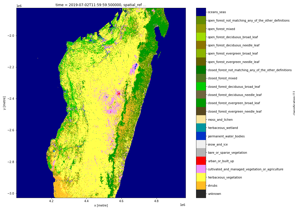
Crédit : Contient le produit CGLS Land Cover 100m, gracieuseté du Copernicus Global Land Service, traité par Digital Earth Africa.
Références
Buchhorn, M. ; Smets, B. ; Bertels, L. ; Lesiv, M. ; Tsendbazar, N.-E.; Masiliunas, D. ; Linlin, L. ; Hérold, M. ; Fritz, S. (2020). Copernicus Global Land Service : Land Cover 100m : Collection 3 : époque 2019 : Globe (Version V3.0.1). Zénodo. DOI : https://10.5281/zenodo.3939049 ;
Marcel Buchhorn, Bruno Smets, Luc Bertels, Bert De Roo, Myroslava Lesiv, Nandin-Erdene Tsendbazar, Linlin Li et Agnieszka Tarko. (2020). Copernicus Global Land Service : Couverture terrestre 100 m : version 3 Globe 2015-2019 : Manuel d’utilisation du produit (jeu de données v3.0, doc issue 3.3). Zenodo. https://doi.org/10.5281/zenodo.3938963
Marcel Buchhorn, Luc Bertels, Bruno Smets, Bert De Roo, Myroslava Lesiv, Nandin-Erdene Tsendbazar, Dainius Masiliunas et Linlin Li. (2020). Copernicus Global Land Service : Land Cover 100m : version 3 Globe 2015-2019 : Document de base théorique de l’algorithme (Dataset v3.0, doc issue 3.3). Zénodo. https://doi.org/10.5281/zenodo.3938968
Nandin-Erdene Tsendbazar, Agnieszka Tarko, Linlin Li, Martin Herold, Myroslava Lesiv, Steffen Fritz et Victor Maus. (2020). Copernicus Global Land Service : Couverture terrestre 100 m : version 3 Globe 2015-2019 : rapport de validation (ensemble de données v3.0, doc issue 1.0). Zenodo. https://doi.org/10.5281/zenodo.3938974
Licence
En tant que produit officiel de la composante mondiale du Copernicus Land Service, l’accès à cet ensemble de données de couverture terrestre, CGLS_LC100m, est entièrement gratuit et ouvert à tous les utilisateurs.
Remerciements
Le produit Copernicus Global Land Service Annual Dynamic Global Land Cover à une résolution spatiale de 100 m a été généré par la composante mondiale du service terrestre de Copernicus, le programme d’observation de la Terre de la Commission européenne. Les recherches ayant conduit à la version actuelle du produit ont reçu un financement de divers programmes de recherche et de développement technique de la Commission européenne. Le produit est basé sur les données PROBA-V fournies par le Service fédéral de la politique scientifique belge (BELSPO) et distribuées par VITO.
Accès aux données
Amazon Web Service
Le produit Copernicus Global Land Service Land Use/Land Cover à 100 m est disponible dans AWS S3.
Tableau 3 : Détails d’accès aux données AWS.
Détails AWS S3 |
|
|---|---|
Seau ARD |
|
Région |
|
Le bucket se trouve dans la région AWS « af-south-1 » (Le Cap). Des spécifications de région supplémentaires peuvent être appliquées comme suit :
aws s3 ls --region=af-sud-1 s3://deafrica-input-datasets/
Les chemins d’accès aux fichiers suivent le format : s3://deafrica-input-datasets/cgls_landcover/<year>/.
Services Web OGC (OWS)
Le produit Copernicus Global Land Service, Land Use/Land Cover at 100 m n’est pas encore disponible via l’OWS de Digital Earth Africa.
Open Data Cube (ODC)
Le produit Copernicus Global Land Service Land Use/Land Cover at 100 m est accessible via l’API ODC de Digital Earth Africa, qui est disponible via le « Digital Earth Africa Sandbox <https://sandbox.digitalearth.africa/hub/login> »__.
Nom du produit ODC : « cgls_landcover »
Des bandes de données spécifiques peuvent être appelées en utilisant soit les noms par défaut, soit l’un des noms alternatifs d’une bande, comme indiqué dans le tableau ci-dessous. Les commandes ODC Datacube.load sans bandes spécifiées chargeront toutes les bandes.
Tableau 4 : noms des bandes de couverture terrestre du produit ODC cgls.
Nom du groupe |
Noms alternatifs |
Remplir la valeur |
|---|---|---|
classification |
classe |
« 255 » |
type_de_forêt |
« 255 » |
|
classification_probabilité |
probablement |
« 255 » |
fraction_de_couverture_nue |
nu |
« 255 » |
fraction_de_couverture_construite |
construit |
« 255 » |
fraction_de_couverture_des_cultures |
cultures |
« 255 » |
fraction_de_couverture_herbeuse |
herbe |
« 255 » |
fraction_de_couverture_moussée |
moussu |
« 255 » |
fraction_de_couverture_en_eau_permanente |
eau permanente |
« 255 » |
fraction_de_couverture_en_eau_saisonnière |
eau de saison |
« 255 » |
fraction_de_couverture_arbustive |
arbuste |
« 255 » |
fraction_de_couverture_neigeuse |
neige |
« 255 » |
fraction_de_couverture_arborée |
arbre |
« 255 » |
Informations techniques
Français La précision globale mondiale de 2019 et la précision globale au niveau continental pour l’Afrique de la couche de couverture terrestre discrète du produit CGLS_LC100m au niveau 1 sont respectivement de « 80,3 % » et « 80,0 % ». Au niveau 2, la précision globale mondiale et la précision globale au niveau continental pour l’Afrique sont respectivement de « 75,1 % » et « 76,5 % ». Dans la couche de couverture terrestre discrète de niveau 1, les classes de forêts fermées et ouvertes ne sont pas séparées alors qu’au niveau 2, elles le sont.
Pour plus d’informations sur la validation de la couche de couverture terrestre discrète et des couches de couverture terrestre fractionnelle du produit CGLS_LC100m, consultez le rapport de validation « Copernicus Global Land Service : Land Cover 100m : version 3 Globe 2015-2019 <https://doi.org/10.5281/zenodo.4723975> ».