ESRI Global Land Use Land Cover
Date modified: 02 August 2022
Product Overview
Background
The ESRI global land use land cover (LULC) map at 10 meter resolution was developed by the Impact Observatory (IO) with the Environmental Systems Research Institute (ESRI) and in patnership with Microsoft AI for Earth.
Digital Earth Africa provides free and open access to a copy of the ESRI/IO Land Cover product over Africa.
A Jupyter Notebook which demonstrates loading and using landcover datasets in the Sandbox is also available.
Specifications
Spatial and temporal coverage
Relevant metadata for the ESRI/IO Land Cover product can be viewed on the DE Africa Metadata Explorer.
Table 1: ESRI/IO Land Cover product specifications
Specification |
|
|---|---|
Product name |
|
Cell size - X (degrees) |
0.0000898° (~10m) |
Cell size - Y (degrees) |
0.0000898° (~10m) |
Coordinate reference system |
|
Temporal resolution |
Annual |
Temporal range |
2017 - 2021 |
Update frequency |
Annual |
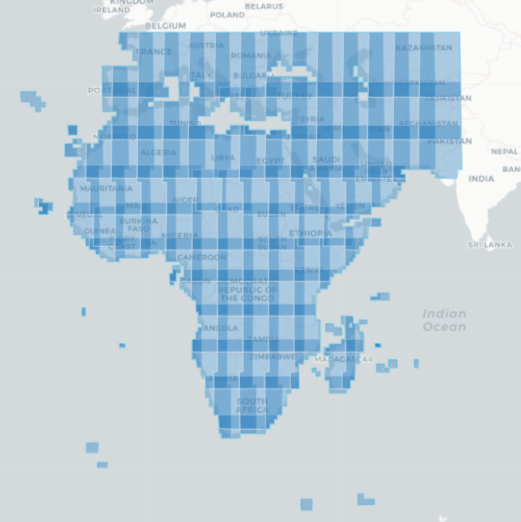
The specific temporal and geographic extents for the product can be explored as an interactive map on the DE Africa Metadata Explorer. Data is available for the region shaded in blue.
Figure 1: ESRI/IO Land Cover product geographic extent
Measurements
Table 2: ESRI/IO Land Cover product measurements
Band ID |
Description |
Units |
Data type |
No data\(^\dagger\) |
|---|---|---|---|---|
data |
Land cover classification |
1 |
uint8 |
0 |
Processing
The ESRI/IO global LULC map is derived from the European Space Agency (ESA) Sentinel-2 imagery. A deep learning AI land classification model was trained using a massive training dataset curated by the National Geographic Society. This dataset contains over 5 billion hand-labelled Sentinel-2 imagery pixels, from 6 bands of surface reflectance data: visible blue, green, red, near infrared, and two shortwave infrared bands. The pixels were sampled from over 20,000 sites distributed across all major biomes of the world.
The UNET, deep learning model was applied to multiple ESA Sentinel-2 scenes across a year, accessed via Microsoft’s Planetary Computer and scaled using Microsoft Azure Batch. The images were classified into 9 discrete land use/land cover classes. The LULC predictions were then composited to generate a representative map of the year.
The original Esri 2020 Land Cover collection uses 10 classes and an older version of the underlying deep learning model. This new map uses an updated model from the 10-class model and combines Grass(formerly class 3) and Scrub (formerly class 6) into a single Rangeland class (class 11).
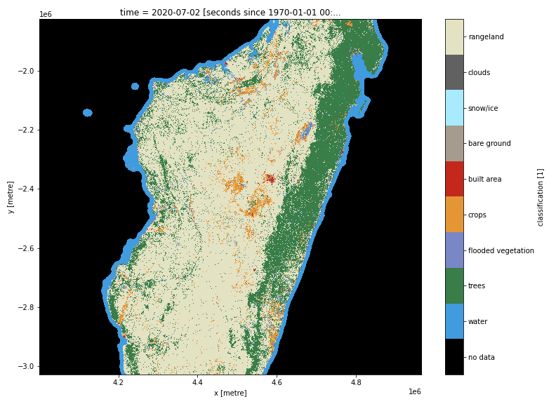
Media and example images
Figure 2: ESRI/IO Land Cover classification for Madagascar in 2020
References
Karra, C. Kontgis, Z. Statman-Weil, J. C. Mazzariello, M. Mathis and S. P. Brumby, “Global land use / land cover with Sentinel 2 and deep learning,” 2021 IEEE International Geoscience and Remote Sensing Symposium IGARSS, 2021, pp. 4704-4707, doi: 10.1109/IGARSS47720.2021.9553499.
Kontgis, C. (2021, June 24). Mapping the world in unprecedented detail
License and Acknowledgements
This data is licensed under a Creative Commons by Attribution (CC BY 4.0) license.
Credits: Impact Observatory, Microsoft, and Esri
Data Acess
OGC Web Services (OWS)
The ESRI/IO Land Cover product io_lulc is available through the Digital Earth Africa’s OWS.
Table 3: OWS data access details.
OWS details |
|
|---|---|
Name |
|
Web Map Services (WMS) URL |
|
Web Coverage Service (WCS) URL |
|
Layer name |
|
Digital Earth Africa OWS details can be found at https://ows.digitalearth.africa/.
For instructions on how to connect to OWS, see this tutorial.
Open Data Cube (ODC)
The ESRI/IO Land Cover product can be accessed through the Digital Earth Africa ODC API, which is available through the Digital Earth Africa Sandbox.
ODC product name: io_lulc
The io_lulc product has only one specific band of data which can be called by using the default name, data, or by the band’s alternative name, classification, as listed in the table below. ODC Datacube.load commands without specified bands will load the data band.
Table 4: ODC product io_lulc band names.
Band name |
Alternative names |
Fill value |
|---|---|---|
data |
classification |
|
Technical information
Accuracy assessment of the ESRI 2020 Land Cover
The original Esri 2020 Land Cover collection uses 10 classes and an older version of the underlying deep learning model.
Following best practices for accuracy assessment, Impact Observatory adjusted the acreage estimates for each land cover class in the ESRI 2020 Land Cover product using its respective user’s accuracy as computed from the comparison to the validation set. The deep learning land cover classification model achieved an overall accuracy of 86% on the validation set. This approach also allowed Impact Observatory to produce a 95% confidence interval for each acreage estimate, providing users with a clearer picture of the accuracy and total area for each class. (From the ESRI release page)
Figure 3: Confusion matrix of pixel counts evaluated against “three expert strict” gold standard validation tiles
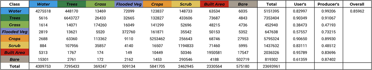
Image courtesy of ESRI.