Rainfall estimates (CHIRPS)
Date modified: 12 January 2022
Product overview
Background
Digital Earth Africa (DE Africa) provides free and open access to a copy of the Climate Hazards Group InfraRed Precipitation with Station data (CHIRPS) monthly and daily products over Africa. The CHIRPS rainfall maps are produced and provided by the Climate Hazards Center in collaboration with the US Geological Survey, and use both rain gauge and satellite observations.
The CHIRPS-2.0 Africa Monthly dataset is regularly indexed to DE Africa from the CHIRPS monthly data. The CHIRPS-2.0 Africa Daily dataset is likewise indexed from the CHIRPS daily data. Both products have been converted to cloud-opitmized GeoTIFFs, and can be accessed through DE Africa’s Open Data Cube. This means the full archive of CHIRPS daily
and monthly rainfall can be easily used for inspection or analysis across DE Africa platforms, including the user-interactive DE Africa Map.
A Jupyter Notebook which demonstrates loading and using CHIRPS datasets in the Sandbox is also available.
This page details how to access CHIRPS products through DE Africa platforms. For more information on the dataset, see the official CHIRPS website:
“Estimating rainfall variations in space and time is a key aspect of drought early warning and environmental monitoring. An evolving drier-than-normal season must be placed in a historical context so that the severity of rainfall deficits can be quickly evaluated. However, estimates derived from satellite data provide areal averages that suffer from biases due to complex terrain, which often underestimate the intensity of extreme precipitation events. Conversely, precipitation grids produced from station data suffer in more rural regions where there are less rain-gauge stations. CHIRPS was created in collaboration with scientists at the USGS Earth Resources Observation and Science (EROS) Center in order to deliver complete, reliable, up-to-date data sets for a number of early warning objectives, like trend analysis and seasonal drought monitoring.”
Specifications
Spatial and temporal coverage
DE Africa provides the monthly and daily CHIRPS datasets as two seperate products.
Table 1: Rainfall CHIRPS products’ specifications
Specification |
||
|---|---|---|
Product name |
Rainfall - CHIRPS daily |
Rainfall - CHIRPS monthly |
Cell size - X (degrees) |
0.05 (~5 km) |
0.05 (~5 km) |
Cell size - Y (degrees) |
0.05 (~5 km) |
0.05 (~5 km) |
Coordinate reference system |
EPSG: 4326 |
EPSG: 4326 |
Temporal resolution |
1 day |
1 month |
Temporal range |
1981 – present |
1981 – present |
Update frequency |
Daily |
Monthly |
Table 2: Rainfall CHIRPS products’ measurements
Product name |
Band ID |
Description |
Units |
Data type |
No data value |
|---|---|---|---|---|---|
Rainfall - CHIRPS daily |
rainfall |
Monthly Atmospheric Precipitation |
|
|
|
Rainfall - CHIRPS monthly |
rainfall |
Daily Atmospheric Precipitation |
|
|
|
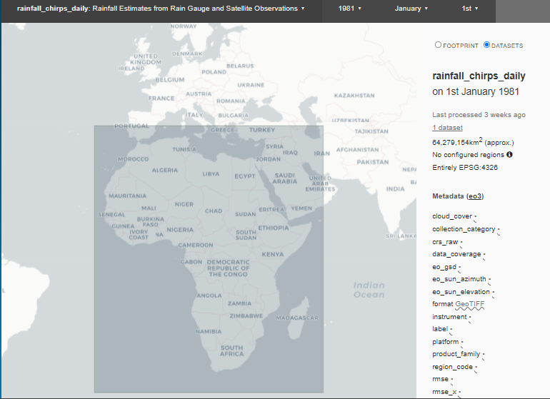
Both rainfall CHIRPS products have the same geographic extent. Data is available for the region shaded in Figure 1.
Specific temporal and geographic extents can be explored as an interactive map on the Digital Earth Africa Metadata Explorer:
Figure 1: CHIRPS products’ geographic extent
Processing
The Climate Hazards group Infrared Precipitation with Stations (CHIRPS) algorithm was developed by the Climate Hazards Center and is described in Funk, C., Peterson, P., Landsfeld, M. et al. (2015).
Media and example images
Image 1: Animation of monthly Rainfall CHIRPS over Nigeria from 2020 to 2021.
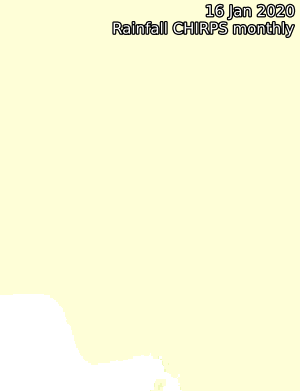
Credit: Contains Rainfall CHIRPS Product courtesy of the Climate Hazards Center, processed by Digital Earth Africa.
Image 2: Mean monthly rainfall for 2020, calculated using monthly CHIRPS rainfall.
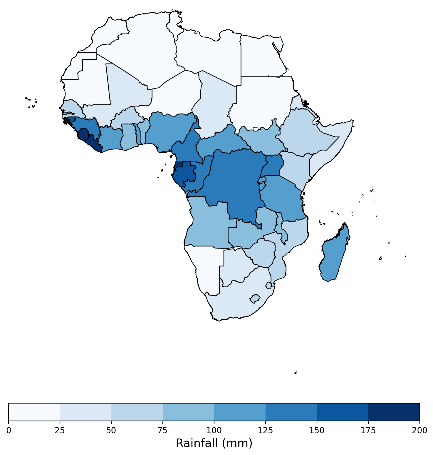
Credit: Contains Rainfall CHIRPS Product courtesy of the Climate Hazards Center, processed by Digital Earth Africa.
References
Funk, C., Peterson, P., Landsfeld, M. et al. (2015). The climate hazards infrared precipitation with stations—a new environmental record for monitoring extremes. Sci Data 2, 150066. https://doi.org/10.1038/sdata.2015.66
License
CHIRPS data is in the public domain as registered with Creative Commons. From the CHIRPS website:
To the extent possible under the law, Pete Peterson has waived all copyright and related or neighboring rights to Climate Hazards Group Infrared Precipitation with Stations (CHIRPS).
Acknowledgements
The CHIRPS monthly and daily products are provided by the Climate Hazards Center (CHC), UC Santa Barbara.
Data Access
Amazon Web Service S3
The Digital Earth Africa CHIRPS products are available in AWS S3.
Table 3: AWS data access details
AWS S3 details |
|
|---|---|
Bucket ARN |
|
Region |
|
Product name |
|
The bucket is in the AWS region af-south-1 (Cape Town). Additional region specifications can be applied as follows:
aws s3 ls --region=af-south-1 s3://deafrica-input-datasets/
The following file path conventions apply to the rainfall_chirps_monthly and rainfall_chirps_daily products respectively:
s3://deafrica-input-datasets/rainfall_chirps_monthly/
s3://deafrica-input-datasets/rainfall_chirps_daily/<year>/<month>/
OGC Web Services (OWS)
The CHIRPS product rainfall_chirps_monthly is available through Digital Earth Africa’s OWS.
Table 4: OWS data access details
OWS details |
|
|---|---|
Name |
|
Web Map Services (WMS) URL |
|
Web Coverage Service (WCS) URL |
|
Layer name |
|
Digital Earth Africa OWS details can be found at https://ows.digitalearth.africa/.
For instructions on how to connect to OWS, see this tutorial.
Open Data Cube (ODC)
CHIRPS products can be accessed through the Digital Earth Africa ODC API, which is available through the Digital Earth Africa Sandbox.
ODC product names: rainfall_chirps_monthly, rainfall_chirps_daily
The rainfall_chirps_monthly and rainfall_chirps_daily products have only one band of data, rainfall, which can be called by using the band name as listed in the table below. ODC Datacube.load commands without specified measurements will also load the rainfall band.
Table 5: Rainfall - CHIRPS ODC products and band names
Product name |
Band name |
Alternative names |
|---|---|---|
|
rainfall |
– |
|
rainfall |
– |
Product names and band names are case-sensitive.
Instructions on how to access and use CHIRPS products from the DE Africa Open Data Cube are provided in the Rainfall CHIRPS dataset example notebook.
Technical Information
Climate Hazards Group InfraRed Precipitation with Station data (CHIRPS) is a 35+ year quasi-global rainfall data set, spanning 50°S-50°N (and all longitudes) and ranging from 1981 to near-present. CHIRPS incorporates the Climate Hazards group Precipitation climatology (CHPclim) that incorporates satellite information to represent sparsely gauged locations, 0.05° resolution satellite-only CCD-based Climate Hazards group Infrared Precipitation (CHIRP) estimates, and in-situ station data to create gridded rainfall time series for trend analysis and seasonal drought monitoring.
For more information on the algorithm used to generate the CHIRPS datasets visit the CHIRPS pulication.